Landmark: Ca Mau Cape
City: Ca Mau
Country: Vietnam
Continent: Asia
Ca Mau Cape, Ca Mau, Vietnam, Asia
Ca Mau Cape is the southernmost point of mainland Vietnam, located in Ngoc Hien District, Ca Mau Province.
Visual Characteristics
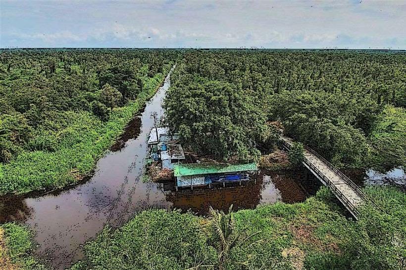
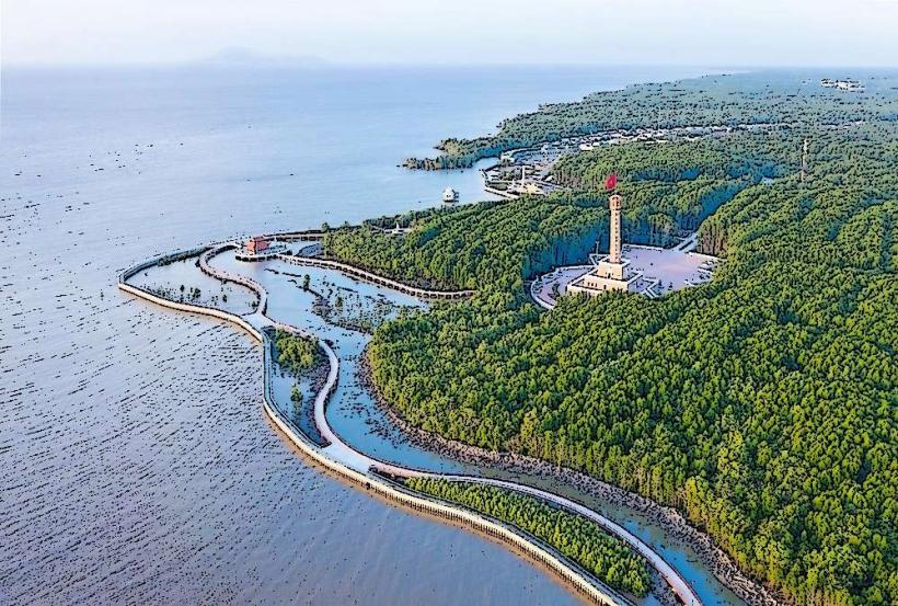
The cape features a flat, alluvial plain with mangrove forests and coastal mudflats. The coastline is characterized by sandy beaches and tidal channels. The national park area is dominated by dense mangrove vegetation, primarily Rhizophora and Avicennia species.
Location & Access Logistics
Ca Mau Cape is approximately 100 kilometers south of Ca Mau City. Access is primarily via Highway 1A to Ngoc Hien District, followed by local roads to the cape. Boat transport is also a common method, with services operating from various points along the coast. Parking is available at designated points near the national park entrance, though capacity can be limited during peak periods. Public bus lines connect Ca Mau City to Ngoc Hien District.
Historical & Ecological Origin
Ca Mau Cape is a geologically recent landmass formed by alluvial deposits carried by the Mekong River and deposited along the coast. The area is part of the Mekong Delta's extensive mangrove ecosystem, which plays a crucial role in coastal protection and biodiversity.
Key Highlights & Activities
Visitors can observe the national flag monument at the geographical marker of the southernmost point. Walking trails through the mangrove forests are accessible. Birdwatching is a primary activity due to the diverse avian population. Boat tours offer exploration of the waterways and mangrove systems.
Infrastructure & Amenities
Restrooms are available at the national park entrance and visitor center. Limited shade is provided by natural tree cover and some constructed shelters. Cell phone signal (4G) is generally available in the vicinity of the visitor center but can be intermittent within the mangrove areas. Food vendors are present near the main access points.
Best Time to Visit
The dry season, from December to April, offers the most favorable weather conditions with less rainfall. The best time of day for photography is generally early morning or late afternoon to avoid harsh sunlight. Tidal patterns do not significantly impact access to the main viewing areas.
Facts & Legends
The national park at Ca Mau Cape is a UNESCO Biosphere Reserve, recognized for its ecological significance. A local legend speaks of a mythical sea creature that guards the southernmost waters, though no scientific evidence supports this.
Nearby Landmarks
- U Minh Ha National Park (30km Northwest)
- Hon Khoai Island (15km Southwest)
- Ca Mau City Center (100km North)
- Dam Doi National Park (60km North)