Landmark: Choirokoitia
City: Larnaca
Country: Cyprus
Continent: Europe
Choirokoitia, Larnaca, Cyprus, Europe
Choirokoitia is a Neolithic archaeological site located in southern Cyprus, approximately 6 km from the southern coast. It is situated within the Larnaca District, near the village of Choirokoitia.
Visual Characteristics
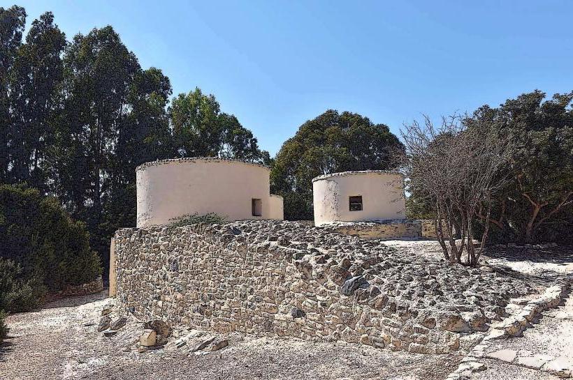
The site consists of the remains of a prehistoric settlement characterized by its distinctive circular dwellings. These structures feature lower walls constructed from local limestone and river stones, with upper sections made of sun-dried mudbricks. The reconstructed huts on site demonstrate conical or domed roofs, likely made of branches and mud. The settlement is terraced on a hillside, with dwellings varying in diameter from 2.3 meters to 9.2 meters. The overall appearance is that of a compact, organized village built into the natural landscape.
Location & Access Logistics
Choirokoitia is located off the A1 highway, which connects Larnaca and Limassol. From Larnaca city center, the site is approximately 32 km southwest, a drive of about 30 minutes. From Limassol city center, it is approximately 35 km northeast, also about a 30-minute drive. Visitors should take exit 14 (Choirokoitia/Vavla) from the A1. A dedicated parking area is available directly at the site entrance. Public transport options are limited; local bus routes may serve the nearby village of Choirokoitia, but direct access to the archaeological site typically requires a taxi or private vehicle.
Historical & Ecological Origin
Choirokoitia is a significant archaeological site dating back to the Pre-Pottery Neolithic B period, with evidence of occupation from approximately 7000 BC to 4000 BC. It represents one of the earliest permanent human settlements on the island of Cyprus. The site was discovered in 1934 by Porphyrios Dikaios and was continuously excavated until 1976. Its original purpose was a self-sufficient agricultural community, demonstrating early forms of organized living, farming, and animal husbandry. The site was inscribed as a UNESCO World Heritage Site in 1998.
Key Highlights & Activities
Visitors can walk through the excavated remains of the original Neolithic settlement, observing the stone foundations of the circular houses. Several full-scale reconstructed dwellings provide an immersive experience of the living conditions. A small visitor center offers interpretive displays and artifacts found during excavations. Informational panels are placed throughout the site, detailing the history and significance of various sections.
Infrastructure & Amenities
The site includes modern restroom facilities near the entrance. Limited shade is available from a few trees and within the reconstructed huts. Cell phone signal (4G/5G) is generally reliable across the site. A small kiosk or vending machine may offer bottled water and snacks, but substantial food vendors are not present directly at the site. The nearby village of Choirokoitia offers a few traditional tavernas.
Best Time to Visit
The best time to visit Choirokoitia for comfortable exploration is during the cooler months of spring (March-May) and autumn (September-November), when temperatures are mild. During summer, early morning or late afternoon visits are recommended to avoid the peak heat and harsh midday sun, which also provides optimal lighting for photography. The site is open year-round, and no specific tide requirements affect access.
Facts & Legends
A unique characteristic of Choirokoitia is the discovery of collective burials beneath the floors of the houses, often with the deceased placed in a contracted position. Some skulls were removed and plastered, suggesting early ancestor veneration practices. The site also provides evidence of a sophisticated defensive wall, indicating a need for protection against external threats or natural elements, a rare feature for settlements of this period.
Nearby Landmarks
- Kalavasos-Tenta: 5 km East
- Tochni Village: 3 km North
- Governor's Beach: 10 km Southwest
- Vavla Village: 4 km North