Landmark: Cottonera Lines
City: Zabbar
Country: Malta
Continent: Europe
Cottonera Lines, Zabbar, Malta, Europe
Visual Characteristics
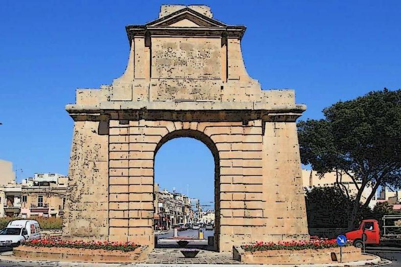
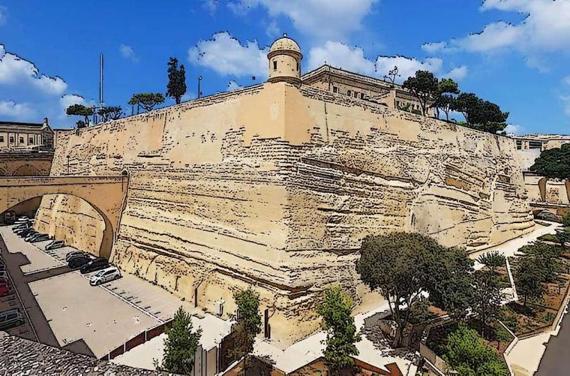
The Cottonera Lines are primarily constructed from local globigerina limestone, exhibiting a pale yellow to honey-colored hue. The fortifications span approximately 4.5 kilometers in length, featuring eight bastions, two demi-bastions, and a continuous curtain wall. The average height of the walls varies, reaching up to 15 meters in some sections, with a deep rock-cut ditch fronting much of the perimeter. The architectural style is typical of 17th-century Baroque military engineering, characterized by robust, angled bastions and strategically placed gates.
Location & Access Logistics
The Cottonera Lines encircle the Three Cities, with significant portions accessible from Zabbar. From the center of Zabbar, the lines are approximately 1-2 kilometers west, accessible via roads such as Triq il-Kunsill ta' l-Ewropa or Triq il-Mina ta' Hompesch. Street parking is available in residential areas adjacent to the walls, though it can be limited. Public transport options include several bus routes; for example, bus routes 91, 94, and 124 connect Zabbar to areas near the lines, with stops along Triq Santa Tereza or Triq San Dwardu providing access points.
Historical & Ecological Origin
Construction of the Cottonera Lines commenced in 1670 under the Order of St. John, following designs by the Italian military engineer Antonio Maurizio Valperga. Their original purpose was to provide a second line of defense for the Grand Harbour area, supplementing the existing Floriana Lines and protecting the rapidly expanding populations of the Three Cities. The project was largely unfinished due to a plague outbreak and financial constraints, though significant portions were completed and later utilized.
Key Highlights & Activities
Visitors can walk along sections of the outer perimeter, particularly near St. Helen's Gate in Cospicua or the areas bordering Zabbar, to observe the scale of the fortifications. Exploring the deep rock-cut ditch is possible in certain accessible sections. Photography of the bastions and curtain walls is a common activity, offering perspectives on 17th-century military architecture. Specific walking trails are not formally designated along the entire length, but local paths allow for exploration.
Infrastructure & Amenities
Restroom facilities are not directly available along the Cottonera Lines themselves; visitors must utilize facilities in the nearby towns of Cospicua, Vittoriosa, Senglea, or Zabbar. Shade is minimal directly on the walls, though some trees line adjacent roads. Cell phone signal (4G/5G) is generally strong throughout the area. Food vendors and cafes are not present directly on the fortifications but are readily available within a short walking distance in the surrounding urban areas.
Best Time to Visit
The best time to visit for comfortable walking and exploration is during the cooler months, from October to April, when temperatures are milder. Early morning or late afternoon hours are recommended for photography, as the low sun angle enhances the texture and depth of the limestone walls. There are no specific high/low tide requirements as the lines are land-based fortifications.
Facts & Legends
The Cottonera Lines were named after Grand Master Nicolas Cotoner, who initiated their construction. Despite their massive scale and strategic importance, the lines were never fully completed according to the original plans, leaving several bastions and sections of the ditch unfinished. A local legend suggests that the immense cost and labor involved in their construction contributed significantly to the Order's financial strain, leading to a period of economic hardship for Malta.
Nearby Landmarks
- Fort Ricasoli: 2.5km North-East
- Fort St. Angelo: 1.5km West
- Inquisitor's Palace: 1.2km West
- Malta at War Museum: 1.0km West
- Gardjola Gardens: 1.8km West