Landmark: Mont Blanc Bridge
City: Geneva
Country: Switzerland
Continent: Europe
Mont Blanc Bridge, Geneva, Switzerland, Europe
The Mont Blanc Bridge (Pont du Mont-Blanc) is the primary traffic and pedestrian artery of Geneva, spanning the point where Lake Geneva flows into the Rhône River. It serves as the physical and symbolic boundary between the lake and the river.
Visual Characteristics
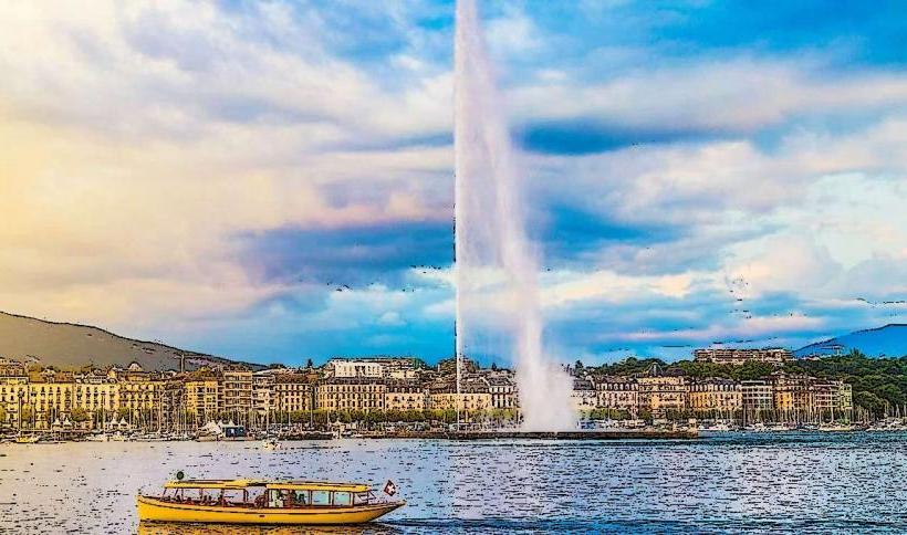
The bridge is a 252-meter-long steel and concrete structure. Its most prominent visual feature is the row of flags representing the 26 Swiss cantons and the City of Geneva, which line both sides of the bridge and flutter in the wind. The bridge provides an unobstructed view of the Jet d'Eau to the east and the Rousseau Island (Île Rousseau) to the west.
Location & Access Logistics
Address: Pont du Mont-Blanc, 1204 Geneva.
Connectivity: It connects the Rive Droite (Right Bank, near the Gare Cornavin) with the Rive Gauche (Left Bank, near the Jardin Anglais).
Access: The bridge carries seven lanes of vehicle traffic, two sidewalks, and bicycle lanes. It is a 5-minute walk from the "Mont-Blanc" or "Métropole" bus/tram stops.
Transport: Major bus and tram lines cross the bridge, including lines 2, 7, 10, and 25.
Historical Origin
The first bridge on this site was a wooden structure built in 1862. It was replaced in 1903 by a steel bridge to accommodate the increasing weight of trams and motor vehicles. The current structure underwent significant reinforcement and widening in 1965–1970 to handle modern traffic volumes.
Key Highlights & Activities
The Panoramic View: This is the most popular vantage point for photographing the Jet d'Eau with the Mont Blanc massif in the background.
Flag Display: The cantonal flags are a permanent fixture, often replaced by international flags during high-level UN summits or state visits.
Lake-to-River Transition: Visitors can observe the distinct change in water current as the lake water funnels into the Rhône.
Infrastructure & Amenities
The bridge is a major transit hub. Wide sidewalks provide safe passage for thousands of pedestrians daily. There are no seating areas on the bridge itself due to high foot traffic. 5G signal is exceptionally strong across the entire span.
Best Time to Visit
Photography: Sunrise provides direct light on the Mont Blanc mountain range. Sunset offers silhouette views of the city's "Bassin" (lake basin).
Events: During the Escalade festival or the Lake Parade, the bridge becomes a central corridor for festivities.
Facts & Legends
The "Bise" Wind: During winter, the bridge is subject to the full force of the north wind (the Bise), which can cause freezing spray from the lake to coat the railings in thick ice.
Naming: It is named after the Mont Blanc mountain, which is clearly visible from the bridge on clear days, despite being located approximately 70 km away.
Nearby Landmarks
Jardin Anglais & Flower Clock – 0.1 km South (Left Bank)
Île Rousseau – 0.1 km West (Downstream)
Jet d'Eau – 0.6 km East
Brunswick Monument – 0.3 km North (Right Bank)
Bains des Pâquis – 0.7 km Northeast