Information
Landmark: Ruins of IsimilaCity: Iringa
Country: Tanzania
Continent: Africa
Ruins of Isimila, Iringa, Tanzania, Africa
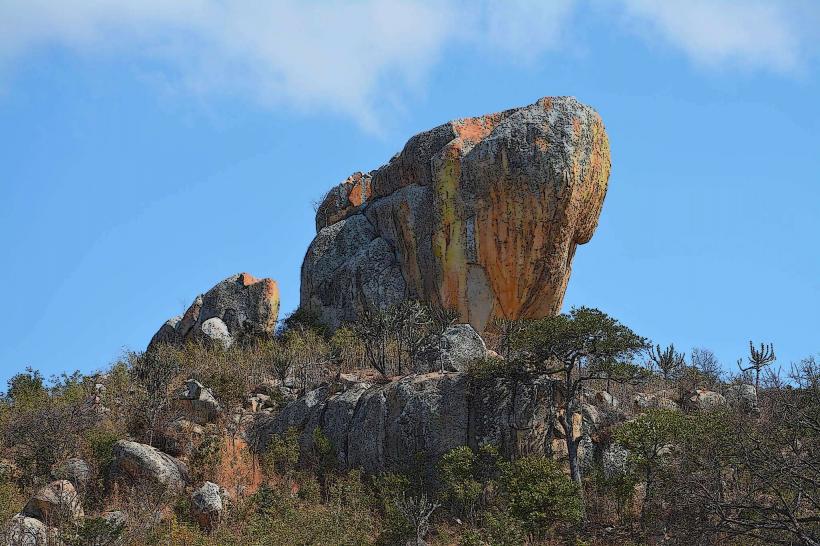
The Ruins of Isimila are a geological formation located in the Iringa Region of Tanzania. These formations are characterized by a series of sandstone pillars and hoodoos.
Visual Characteristics
The site features numerous sandstone pillars, some reaching heights of up to 30 meters. These pillars exhibit varied erosion patterns, creating distinct shapes and textures. The surrounding landscape is arid, with sparse vegetation consisting primarily of grasses and drought-resistant shrubs. The dominant color palette is ochre and brown, with variations depending on the mineral content of the sandstone.
Location & Access Logistics
The Ruins of Isimila are situated approximately 20 kilometers southwest of Iringa town. Access is via the A104 road, turning off onto a well-maintained gravel track for the final 3 kilometers. Ample parking is available at the designated visitor area. No public transport directly serves the site; private vehicles or hired taxis are the primary means of access.
Historical & Ecological Origin
The formations are the result of long-term erosion of sedimentary rock layers by wind and water. This process has sculpted the sandstone over millennia, creating the distinctive pillar shapes. While not a man-made structure, the site has yielded evidence of early human activity, including stone tools dating back to the Acheulean period, suggesting it was a site of significance for prehistoric hominins.
Key Highlights & Activities
Visitors can walk among the sandstone pillars. Designated pathways guide visitors through the main formations. Photography is a primary activity due to the unique geological structures. No organized tours are currently offered, but self-guided exploration is encouraged.
Infrastructure & Amenities
Basic amenities are present at the visitor area, including pit latrines. There is no direct shade provided by structures, though some natural shade can be found near larger formations. Cell phone signal is intermittent and generally unreliable. No food vendors are located at the site; visitors should bring their own provisions.
Best Time to Visit
The best time of day for photography is during the early morning or late afternoon when the low-angle sunlight creates pronounced shadows and highlights the textures of the sandstone. The dry season, from June to October, offers the most favorable weather conditions with minimal rainfall. There are no tidal considerations at this inland site.
Facts & Legends
Local folklore suggests that the pillars are petrified warriors who were turned to stone for defying a chief. Geologically, the site is significant for its well-preserved evidence of early hominin tool-making activities, indicating a long history of human presence in the area.
Nearby Landmarks
- Iringa Town Center (20km Northeast)
- Kalenga Historical Museum (25km Northeast)
- Ruaha National Park (Approximately 130km Southwest, beyond immediate radius)