Landmark: Slaughter Pen Trail System
City: Bentonville
Country: USA Arkansas
Continent: North America
Slaughter Pen Trail System, Bentonville, USA Arkansas, North America
The Slaughter Pen Trail System is a network of multi-use trails located in Bentonville, Arkansas. It is designed for mountain biking, hiking, and trail running.
Visual Characteristics
The trails traverse varied terrain, including wooded areas with mature deciduous trees, open fields, and rocky outcrops. The trail surfaces consist of packed dirt, gravel, and sections with natural rock features. Elevation changes are moderate, with some steeper ascents and descents. The system includes bridges and boardwalks over wet areas.
Location & Access Logistics
The primary access point is located at the north end of the trail system, adjacent to the Bentonville Community Center at 1101 SW 26th Street, Bentonville, AR 72712. Additional parking is available at the south end near the Crystal Bridges Museum of American Art. The trails are approximately 1.5km from Bentonville's downtown square. Public transport options are limited; the Bentonville Connect bus service may have routes that pass near the community center, but direct trail access via public transit is not guaranteed.
Historical & Ecological Origin
The Slaughter Pen Trail System was developed on land historically used for agriculture and later as a municipal park. The trail construction began in the early 2000s, with significant expansion and professional design occurring in the 2010s to accommodate mountain biking. The area's ecology is characteristic of the Ozark Highlands, featuring a mix of woodland and prairie habitats.
Key Highlights & Activities
The trail system offers over 40 miles of interconnected trails. Specific activities include downhill mountain biking on designated "flow" trails, cross-country riding, hiking, and trail running. The "Ozark Highlands Trail" passes through a portion of the system. Beginner-friendly loops are available, as are more challenging technical sections.
Infrastructure & Amenities
Restrooms are available at the Bentonville Community Center and near the Crystal Bridges Museum. Shaded areas are present within the wooded sections of the trails. Cell phone signal (4G/5G) is generally available throughout most of the trail system, though it may be intermittent in denser wooded areas. Food vendors are not directly located on the trails but are available in downtown Bentonville and near the museum.
Best Time to Visit
The best time for outdoor activities is during the spring (April-May) and fall (September-October) when temperatures are mild and foliage is at its peak. Summer months (June-August) can be hot and humid. Early morning or late afternoon provides optimal lighting for photography, avoiding harsh midday sun. Trail conditions are generally best after dry periods; avoid visiting immediately after heavy rainfall, as some sections can become muddy and slick.
Facts & Legends
The name "Slaughter Pen" is believed to originate from a historical event where cattle were driven through the area. A specific tip for visitors is to utilize the trail maps available online or via mobile apps, as the interconnected nature of the system can be confusing for first-time users. The trail system is directly connected to the trails at Crystal Bridges Museum, allowing for extended exploration.
Nearby Landmarks
- Crystal Bridges Museum of American Art (0.2km South)
- The Momentary (0.8km Southwest)
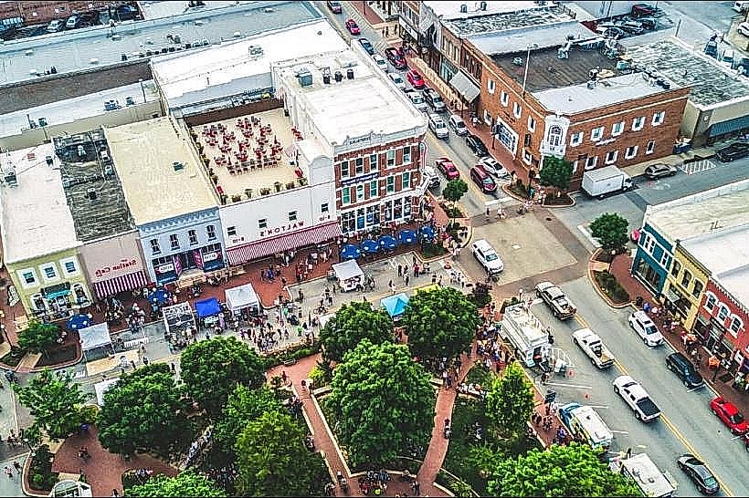
- Bentonville Square (1.5km North)
- Osage Park (2.1km Southeast)
- Lake Bella Vista (4.5km West)