City: Embu
Country: Kenya
Continent: Africa
Embu, Kenya, Africa
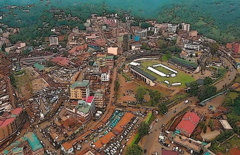
Embu is the administrative capital of Embu County and a major commercial center in the Mount Kenya region. It is situated at an elevation of 1,350 meters on the southeastern foothills of Mount Kenya, approximately 125 kilometers northeast of Nairobi.
Historical Timeline
Embu was founded as a British military and administrative station in 1906. The name is derived from the Embu people (Aembu), the indigenous Bantu-speaking community. The city served as the provincial capital of the former Eastern Province for decades. Its modern identity was forged through its role as a key agricultural collection point for coffee and tea, and more recently, as a hub for endurance athletic training due to its conducive high-altitude climate.
Demographics & Population
The estimated metropolitan population for 2026 is 72,000 (with the broader county population exceeding 650,000). The demographics are predominantly Embu and Mbeere, with significant populations of Kikuyu, Kamba, and Meru. The median age is approximately 20.2 years.
Urban Layout & Key Districts
The town is built on a sloping landscape that descends from west to east.
The CBD: Focused along the Nairobi-Meru highway, featuring regional government offices and commercial banks.
Blue Valley: A prominent middle-income residential district.
Majengo: A high-density residential and commercial zone.
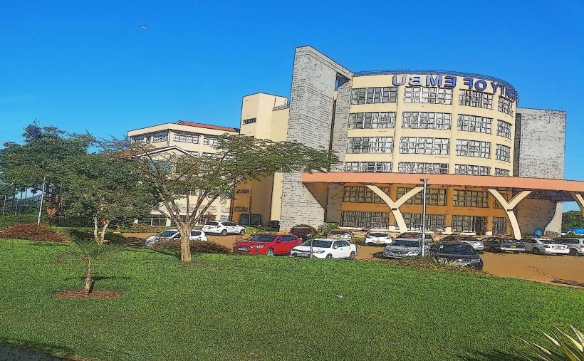
Kangaru: Home to major educational institutions including the University of Embu.
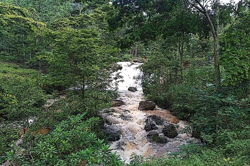
Njukiri: An area known for its forest proximity and growing eco-tourism facilities.
Top City Landmarks
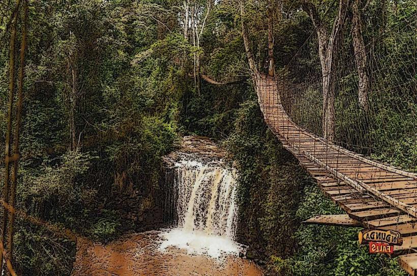
Camp Ndunda Falls: A popular adventure site in Njukiri Forest featuring ziplining, canopy walks, and mud fun.
Mount Kenya National Park (Embu Entry): A less-traveled, scenic gateway to Africa’s second-highest peak.
Iveche Waterfall: A serene natural site located near the University of Embu.
Seven Forks Dams: A series of five major hydroelectric dams (including Masinga and Kiambere) on the Tana River nearby.
Mwea National Reserve: Located south of the town, known for its savannah plains and Hinde’s Babbler bird species.
Transportation Network
Intra-city transit is dominated by Boda Bodas and Matatus. Embu is a critical transit point on the highway linking Nairobi to Meru and the Northern Frontier. Embu Airstrip (1 km long) handles light aircraft and private charters. There is no rail service; the city relies heavily on well-maintained road connections to the capital.
Safety & "Red Zones"
The general safety level is high, with Embu often ranked among the safer urban centers in Kenya. Petty theft occurs in the main market area and the bus park. There are no designated "red zones," though travelers should avoid walking in the outskirts of Majengo alone late at night. The high-altitude terrain requires caution for drivers due to frequent morning mist and fog on the Embu-Meru road.
Digital & Financial Infrastructure
Internet speeds average 25–40 Mbps. Main carriers are Safaricom and Airtel. M-Pesa is the primary payment method for almost all local trade. ATMs are abundant along the main highway and within major shopping hubs like the Embu Naivas. Credit card acceptance is limited to large hotels and supermarkets.
Climate & Air Quality
Temperatures range from 14°C to 28°C. The climate is mild and temperate, with two distinct rainy seasons (March–May and October–December). Air quality is exceptional. A local seasonal highlight is the blooming of Jacaranda trees in October and November, which covers the municipality in purple blossoms.
Culture & Social Norms
English and Swahili are used for business; Kiembu is the primary local language. The culture is agricultural and academic, influenced by the presence of several colleges. Shaking hands is the standard greeting. Modest, functional dress is preferred, especially when visiting rural farms or religious sites.
Accommodation Zones
Izaak Walton Area: Recommended for historic, quiet stays with mature gardens.
Mutunduri / Njukiri: Recommended for eco-lodges and proximity to adventure parks.
Local Cost Index
1 Espresso: 220 KES ($1.45 USD)
1 Standard Lunch (Mukimo/Beef): 600 KES ($3.90 USD)
1 Short Boda Boda Trip: 100 KES ($0.65 USD)
Nearby Day Trips
Karue Hill: 20 km (A dramatic rock outcrop offering views of Mt. Kenya and the eastern plains).
Masinga Dam: 45 km (Boating and sightseeing at Kenya's largest reservoir).
Kirimiri Forest: 15 km (Hiking trails and the Mau Mau caves).
Facts & Legends
Embu is known as the "Land of Opportunities." A local legend states that the Embu people descended from a primal couple, Mwenendega and Ciurunji, who lived in a sacred grove near Runyenjes. A verified historical oddity is that Embu served as a key hideout for Mau Mau fighters due to its dense forests and caves, many of which remain accessible today as historical pilgrimage sites.