
City: Manzini
Country: Eswatini
Continent: Africa
Manzini, Eswatini, Africa
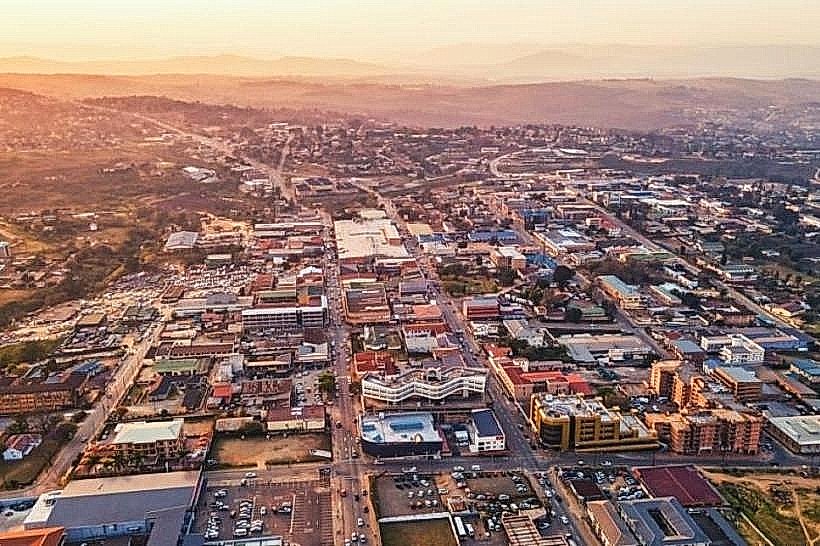
Manzini is the primary industrial and commercial hub of Eswatini, serving as the capital of the Manzini Region. Positioned in the Middleveld region at the geographical center of the country, it sits 35 kilometers southeast of the executive capital, Mbabane, along the MR3 highway.
Historical Timeline
1885: Founded as a trading post by Arthur Bremer, a European concessionaire, who established a store and hotel.
1890: Designated as the initial administrative capital of the joint Boer-British administration under the name Bremersdorp.
1899: Destroyed by Swazi forces during the Anglo-Boer War, prompting the British to relocate the capital to Mbabane.
1960: Renamed Manzini, honoring a local Swazi chief, and officially declared a town.
Primary Urban Event: The establishment of the Matsapha Industrial Estate 7 kilometers west of the town center in 1965 systematically concentrated the nation's manufacturing sector here, locking Manzini into its role as the country's economic and logistics engine.
Demographics & Population
City Limits Population: 78,000
Metropolitan Area Population: 110,000
Top Three Demographics: Swazi (95.2%), Mozambican (2.1%), South African (1.3%).
Median Age: 23.1 years
Urban Layout & Key Districts
Manzini operates on a grid system that radiates from its central commercial core, bounded by the Mzimnene River to the east.
The Central Business District (CBD): The highly concentrated retail core centered around Ngwane Street and the Bhunu Mall.
Matsapha: Located 7 kilometers west, the primary heavy industrial zone containing factories, fuel depots, and dry ports.
Fairview: A sprawling, middle-to-high income residential district located immediately northeast of the CBD across the Mzimnene River.
Top City Landmarks
Manzini Market: A massive covered municipal market operating at the corner of Mancishana and Sandlane Streets, specializing in traditional crafts, wholesale produce, and local medicine.
Bhunu Mall: The primary modern retail development anchoring the central commercial zone.
The Hub: A large shopping complex on the western edge of the CBD catering to regional commuters and logistics traffic.
St. Theresa’s Cathedral: A prominent, modernist Roman Catholic church complex anchoring the city's historical educational and religious sector.
Nazarene Hospital Complex (RFM): The Raleigh Fitkin Memorial Hospital, a massive regional medical compound operating since 1927.
Transportation Network
Manzini is the central transit artery of Eswatini. Internal and regional public transport relies entirely on 15-seater minibuses (kombis) and larger buses operating out of the massive Manzini Bus Rank. No passenger rail or tram systems exist. Private metered taxis are clustered around shopping centers but require telephone booking. King Mswati III International Airport handles commercial flights and is located 45 kilometers east. Traffic density in the CBD is the highest in the country, experiencing severe gridlock daily between 07:30–08:30 and 16:30–17:30.
Safety & "Red Zones"
Manzini has a higher crime rate than Mbabane, driven by its status as a crowded transit hub. Pickpocketing, bag-snatching, and vehicle break-ins are common in congested areas. Avoid the central Manzini Bus Rank, the immediate surroundings of the informal street markets along Ngwane Street, and the unlit residential areas of Zakhele and Moneni after dark. Fake currency scams and illegal informal currency exchangers operate around the bus rank perimeter.
Digital & Financial Infrastructure
Average Internet Speed: 22 Mbps fixed broadband; 14 Mbps mobile.
Main Mobile Carriers: MTN Eswatini, Eswatini Mobile.
Card Acceptance: High in established retail centers, supermarkets, and hotels; cash is mandatory for all transactions at informal markets, kombis, and smaller street vendors.
ATMs: Abundant throughout the CBD (Standard Bank, FNB, Nedbank, SwaziBank). The local currency is the Lilangeni (SZL), which trades at a 1:1 peg with the South African Rand (ZAR). South African Rand notes are accepted universally.
Climate & Air Quality
Manzini features a subtropical climate with high humidity and significantly warmer temperatures than Mbabane due to its lower elevation (537 meters).
Winter (Jun–Aug): 11°C to 25°C; mild, dry, and generally clear. Air quality is fair, though industrial dust increases around Matsapha.
Summer (Dec–Feb): 19°C to 32°C; hot and humid, with severe afternoon convective thunderstorms.
Weather Risks: Extreme heatwaves in January and February can cause temperatures to exceed 38°C.
Culture & Social Norms
Tipping: 10% is standard in formal dining establishments; tipping is not practiced at casual food stalls or inside minibus transport.
Greeting: A verbal greeting ("Yebo") accompanied by a three-part handshake is standard. Addressing elders or business partners with their clan name is a sign of high respect.
Dress Code: Casual but modest. While less rigid than traditional villages, beachwear or overly revealing clothing in the CBD is culturally frowned upon.
Alcohol & Smoking: Drinking alcohol in public streets is illegal. Smoking is banned inside public and commercial buildings and is socially discouraged in open public markets.
Accommodation Zones
Fairview / Upper Residential: Recommended for visitors looking for quieter guesthouses, secure parking, and a buffer from the chaotic noises of the central transit grid.
Central CBD (Near The Hub): Recommended for short-stay logistics, direct walking access to financial institutions, corporate offices, and quick regional highway access.
Local Cost Index
1 Espresso: 34 SZL ($1.89 USD)
1 Standard Lunch (Quarter chicken and chips at local chain): 85 SZL ($4.75 USD)
1 Kombi Transit Ticket (Local urban route): 12 SZL ($0.67 USD)
Nearby Day Trips
Malkerns Valley: A fertile agricultural basin containing craft centers, candle factories, and organic farm shops; 15 km west, reachable via the MR27 in 20 minutes.
Summerfield Botanical Garden: A manicured tropical garden reserve featuring upscale dining and walking paths; 12 km west, accessible via the MR3 road in 15 minutes.
Hlane Royal National Park: Eswatini's largest protected conservation area, hosting elephants, rhinos, and lions; 50 km east, reachable via the MR3 highway in 45 minutes.
Facts & Legends
A widespread local legend surrounds the rapid, unexpected destruction of Bremersdorp in 1899 during the Anglo-Boer War. Local oral history claims that prior to the alignment of Swazi forces with the Boers to burn the settlement, a traditional healer warned colonial merchants that building a Western town on the banks of the Mzimnene River would anger the river’s ancestral water spirits. When the town was razed to the ground months later, forcing the British administration to permanently abandon it for the hills of Mbabane, it was widely attributed to the water spirits reclaiming the valley.