Landmark: Confluence of Rivers Niger and Benue
City: Kogi
Country: Nigeria
Continent: Africa
Confluence of Rivers Niger and Benue, Kogi, Nigeria, Africa
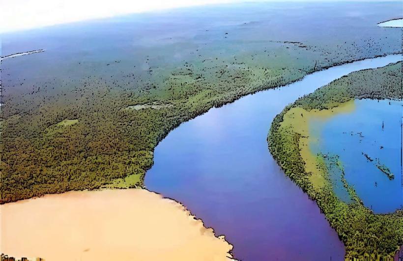
The confluence of the Niger and Benue rivers is a geographical point located in Kogi State, Nigeria. This site marks the meeting point of two major West African waterways.
Visual Characteristics
The confluence is characterized by the distinct visual separation of the two rivers' waters before they merge. The Niger River water often appears darker, while the Benue River water can be lighter or more turbid depending on seasonal rainfall and sediment load. The surrounding landscape consists of alluvial plains and vegetation typical of a tropical savanna environment.
Location & Access Logistics
The confluence is situated near the city of Lokoja in Kogi State. Access is primarily via road. Lokoja is approximately 200 kilometers north of Abuja, the capital city, accessible via the A2 highway. From Lokoja town center, local transport, including taxis and motorcycles, can reach the vicinity of the confluence. There are no dedicated public transport routes directly to the confluence point itself. Parking is informal and available on the periphery of the accessible areas.
Historical & Ecological Origin
The confluence is a natural geological formation resulting from the convergence of two major river systems. The Niger River originates in Guinea and flows through Mali, Niger, and Nigeria. The Benue River, its largest tributary, originates in Cameroon and flows through Nigeria. The meeting point is a significant hydrological feature of the West African landscape.
Key Highlights & Activities
Observation of the riverine confluence is the primary activity. Boat trips on the rivers are possible, offering different perspectives of the meeting point. Fishing is practiced by local communities in the surrounding areas. Photography of the distinct water colors is a common visitor interest.
Infrastructure & Amenities
Basic amenities are limited at the immediate confluence site. There are no formal restrooms or designated shade structures. Cell phone signal (4G/5G) is generally available in the vicinity of Lokoja town but may be intermittent closer to the riverbanks. Food vendors are typically found in Lokoja town rather than at the confluence itself.
Best Time to Visit
The dry season, from November to March, generally offers clearer water visibility and more stable weather conditions. The best time of day for photography is typically late afternoon, when the sun angle can enhance the contrast between the river waters. High water levels during the rainy season (April to October) can obscure the visual distinction between the rivers.
Facts & Legends
Local folklore often attributes spiritual significance to the confluence, viewing it as a sacred meeting place. A verified historical oddity is that the confluence was a key strategic point during colonial administration, with Lokoja serving as an early administrative center due to its riverine access.
Nearby Landmarks
- Mount Patti (1.5km West)
- Lokoja Old Market (2km West)
- Iron of Liberty (2.5km West)
- National Museum Lokoja (2.2km West)