Landmark: El Pico Turquino
City: Guantanamo
Country: Cuba
Continent: North America
El Pico Turquino, Guantanamo, Cuba, North America
El Pico Turquino is the highest point in Cuba, situated within the Sierra Maestra mountain range in the Granma Province.
It is a significant geographical feature within the national park system of Cuba.
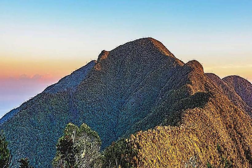
Visual Characteristics
The summit of Pico Turquino is characterized by rocky outcrops and sparse vegetation, primarily consisting of pine trees and shrubs adapted to high altitudes. The terrain is steep and uneven, with exposed rock faces. The surrounding slopes are covered in dense montane forest.
Location & Access Logistics
Pico Turquino is located in the Sierra Maestra National Park. Access is typically from the towns of Bartolomé Masó or Las Coloradas. The primary trailheads are approximately 60 kilometers south of Bayamo. Vehicle access is limited to unpaved park roads, often requiring 4x4 vehicles. Parking is available at designated ranger stations near the trailheads. Public transport to the nearest towns is available, but direct access to the park requires private or arranged transport. The most common access point is from the south, via the road from Bartolomé Masó.
Historical & Ecological Origin
Pico Turquino is a geological formation of sedimentary rock, part of the Sierra Maestra range, which was uplifted during the Tertiary period. Its ecological classification is montane forest and high-altitude scrubland. The peak gained historical significance during the Cuban Revolution, serving as a strategic point for Fidel Castro's forces.
Key Highlights & Activities
Hiking to the summit is the primary activity. There are two main trails: the northern trail from La Platina (approximately 18km one-way) and the southern trail from Las Cuevas (approximately 12km one-way). Both trails are strenuous and require a full day or overnight stay. Camping is permitted at designated sites along the trails. Observation points offer views of the surrounding mountain range and, on clear days, the Caribbean Sea.
Infrastructure & Amenities
Basic infrastructure exists at ranger stations, including rudimentary shelters and water sources. Restrooms are available at some trailheads. Shade is provided by the forest canopy on the trails. Cell phone signal is unreliable and generally absent within the park interior. Food vendors are not present within the park; visitors must carry all provisions.
Best Time to Visit
The best months for visiting are generally from November to April, during the dry season, to avoid heavy rainfall and muddy trails. The best time of day for photography is early morning for softer light and potential cloud inversions. High tide is not a relevant factor for this mountain peak.
Facts & Legends
A unique aspect of Pico Turquino is the presence of a bust of José Martí at the summit, placed there by Fidel Castro. Local lore suggests that the peak's name derives from the indigenous Taíno word "turquino," meaning "blue water," referring to the sea visible from its heights.
Nearby Landmarks
- Sierra Maestra National Park Headquarters (1km West)
- La Demajagua Historical Site (25km Northeast)
- Bayamo City (60km North)
- Las Coloradas Beach (70km Southwest)
- Marea del Portillo (75km Southwest)