Landmark: Höllenkessel Trails
City: Mauren
Country: Liechtenstein
Continent: Europe
Höllenkessel Trails, Mauren, Liechtenstein, Europe
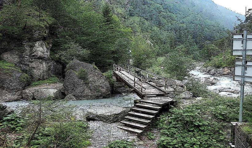
The Höllenkessel Trails are a network of marked hiking paths located in the municipality of Mauren, Liechtenstein. These trails traverse the mountainous terrain on the eastern side of the Rhine Valley.
Visual Characteristics
The trails feature compacted earth and gravel surfaces, winding through mixed deciduous and coniferous forests. Sections offer views of the Rhine Valley and the Rätikon mountain range. Elevation changes are significant, with some paths carved into steep slopes and others following ridge lines. The landscape includes limestone rock formations and dense undergrowth.
Location & Access Logistics
The primary access point for the Höllenkessel Trails is near the Mauren village center. From the center, follow local signage towards Höllenkessel. Limited free parking is available at the trailhead near the Sportplatz Mauren. Public transport is available via LIEmobil bus line 11, with stops such as "Mauren, Post" or "Mauren, Sportplatz" located within walking distance (0.5-1km) of various trail access points.
Historical & Ecological Origin
The Höllenkessel Trails were developed for recreational hiking, utilizing existing forest paths and new constructions to create a structured network. The area is characterized by subalpine forest ecosystems, with dominant tree species including spruce, fir, and beech. The geological formations are typical of the Rätikon Alps, primarily consisting of limestone and dolomite, shaped by glacial activity and erosion.
Key Highlights & Activities
Hiking is the primary activity, with marked trails varying in difficulty and length, suitable for different fitness levels. Specific routes include the loop around the Höllenkessel depression itself, offering panoramic views of the surrounding landscape. Trail running is also common on the more accessible sections. Designated viewpoints provide opportunities for observation of the Rhine Valley.
Infrastructure & Amenities
Basic infrastructure along the trails includes clear trail markers and occasional wooden benches. Restrooms are available in the Mauren village center, approximately 1-2km from the main trailheads, but not directly on the trails. Natural shade is provided by the extensive forest canopy. Cell phone signal (4G/5G) is generally reliable throughout the area. Food vendors and restaurants are located in Mauren village.
Best Time to Visit
The best time to visit the Höllenkessel Trails is from late spring (May) to early autumn (October) when trails are free of snow and ice. Mornings offer cooler temperatures and clearer visibility for photography, especially for views over the Rhine Valley. Visiting during dry periods is recommended, as some sections can become slippery after heavy rainfall.
Facts & Legends
The name Höllenkessel translates to "Hell's Cauldron," referring to a steep, bowl-shaped depression within the terrain. Local lore suggests the area was historically considered wild and difficult to traverse, inspiring its dramatic and evocative name among the local population.
Nearby Landmarks
- Pfrundhaus Mauren: 0.5km South-West
- Mauren Parish Church: 0.4km South
- Schellenberg Castle Ruins: 2.5km North-West
- Ruggeller Riet Nature Reserve: 3.5km North-East
- Eschnerberg (general hiking area): 1.5km West