Landmark: Kiel Canal
City: Kiel
Country: Germany
Continent: Europe
Kiel Canal, Kiel, Germany, Europe
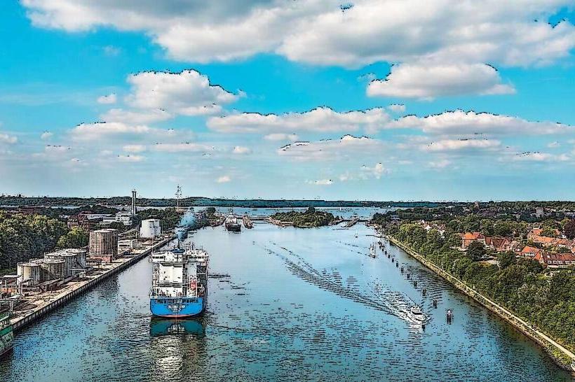
Kiel Canal (Nord-Ostsee-Kanal, or NOK) is the world’s busiest artificial waterway for seagoing vessels, connecting the North Sea at Brunsbüttel to the Baltic Sea at Kiel-Holtenau.
Visual Characteristics
The canal is a 98.6-kilometer freshwater channel cutting through the rural, flat landscape of Schleswig-Holstein. It is characterized by its massive locks at both ends, ten high-level bridges with a clearance of 42 meters, and 16 free ferries that transport cars and pedestrians across. The scenery alternates between industrial lock complexes, green embankments, and historic bridge architecture.
Location & Access Logistics
The eastern terminus is at Kiel-Holtenau, about 6km north of Kiel city center.
Public Transit: From Kiel Hauptbahnhof, take bus lines 11, 12, or 13 to stop "Kiel-Holtenau (Schleuse)" or use the ferry (Fördelinie) to the "Holtenau" pier.
Access: The canal banks are open to the public for walking and cycling. The Schleusenaussichtsplattform (Lock Viewing Platform) in Kiel-Wik offers a direct view of the locking process.
Admission: Small fee (approx. €1.00) for the viewing platform; ferries across the canal are free of charge by law.
Hours: The canal operates 24/7 for shipping. The viewing platform is typically accessible from sunrise to sunset.
Historical Origin
Built between 1887 and 1895 during the reign of Emperor Wilhelm I and opened by Emperor Wilhelm II. It was originally named the Kaiser-Wilhelm-Kanal. The primary purpose was to allow the German Imperial Navy to move between the North Sea and the Baltic without sailing around Denmark (the Jutland Peninsula). It was widened between 1907 and 1914 to accommodate larger Dreadnought-class battleships. It was renamed the "Nord-Ostsee-Kanal" (Kiel Canal) in 1948.
Key Highlights & Activities
Holtenau Locks: Watching massive container ships and cruise liners squeezed into the lock chambers with only centimeters to spare.
Cycling (NOK-Route): A popular 325km long-distance cycle path that follows the canal, offering a completely flat route through the heart of the state.
Rendsburg Transporter Bridge: A unique historic hanging ferry suspended from a massive railway bridge (located halfway between Kiel and Brunsbüttel).
Tiessenkai: A historic quay in Holtenau with old warehouses, traditional sailing ships, and cafes, offering a classic maritime atmosphere.
Infrastructure & Amenities
The banks feature well-maintained gravel paths ideal for cycling and jogging. In the Holtenau area, several restaurants and fish stalls provide local cuisine. The viewing platform in Kiel-Wik is built atop a WWII bunker and includes an exhibition about the canal's history. 5G signal is excellent along the entire urban section of the canal.
Best Time to Visit
Kiel Week (June): When the canal sees an influx of traditional tall ships and international naval vessels.
Summer Afternoons: For watching the "parade" of yachts and cruise ships entering the Baltic.
Facts & Legends
A technical oddity is that the ferries are free because of a 19th-century decree by the Emperor: since the canal severed existing roads, the state was obligated to provide free transit forever. Legend states that during construction, Kaiser Wilhelm II was so obsessed with the project's speed that he personally inspected the site regularly, often "encouraging" workers by timing their progress with his pocket watch.
Nearby Landmarks
Kiel Fjord (Kieler Förde) – Directly adjacent
Schleswig-Holstein State Parliament – 5km South
Laboe Naval Memorial – 8km Northeast (across the Fjord)
Kiel Maritime Museum – 6km South