Landmark: Marafa Depression (Hell's Kitchen)
City: Malindi
Country: Kenya
Continent: Africa
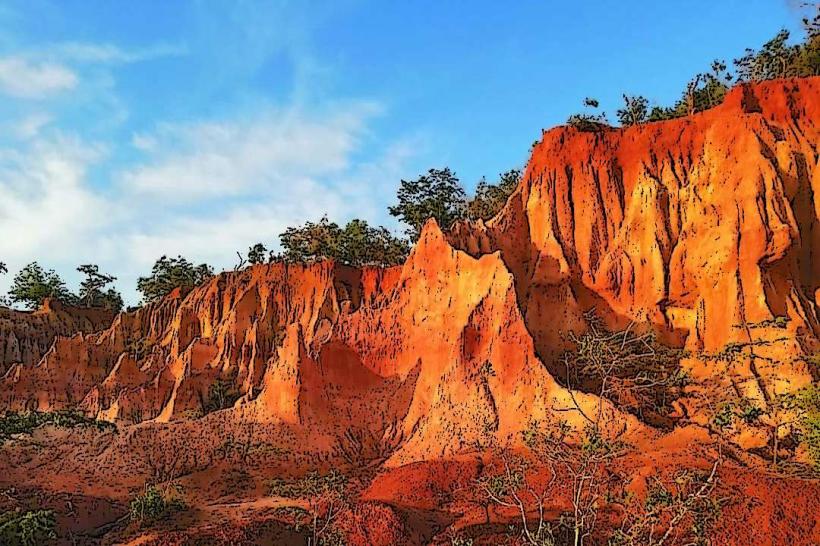
Marafa Depression (Hell's Kitchen), Malindi, Kenya, Africa
The Marafa Depression, commonly known as Hell's Kitchen, is a geological formation located approximately 40 kilometers north of Malindi, Kenya.
Visual Characteristics
This site features a series of deep ravines and canyons carved into sandstone. The exposed rock strata display distinct bands of red, orange, and white, creating a layered appearance. The terrain is arid, with sparse vegetation consisting primarily of drought-resistant shrubs and grasses.
Location & Access Logistics
Access is via the Malindi-Tsavo Road (B8). Approximately 35 kilometers from Malindi, turn north onto a dirt track. The track is approximately 5 kilometers long and requires a 4x4 vehicle for reliable passage, especially during the rainy season. No public transport directly serves the site. Parking is available at the edge of the depression, with informal attendants often present.
Historical & Ecological Origin
The Marafa Depression is a natural geological formation resulting from the erosion of sandstone over millennia by wind and water. The specific geological classification is a series of canyons and gullies within the coastal sandstone formations.
Key Highlights & Activities
Exploration of the canyon floor is possible via designated paths. Guided walks are available, led by local guides who explain the geological features. Photography is a primary activity due to the unique coloration and formations.
Infrastructure & Amenities
Basic amenities are limited. There are no permanent restroom facilities. Shade is minimal, primarily provided by natural rock overhangs. Cell phone signal is unreliable. Small stalls operated by local vendors may offer water and snacks near the entrance.
Best Time to Visit
The best time of day for photography is late afternoon, approximately 15:00 to 17:00, when the low-angle sunlight enhances the colors of the rock formations. The dry season, from June to October, offers the most accessible conditions for travel. Avoid visiting during or immediately after heavy rainfall due to track conditions.
Facts & Legends
Local folklore attributes the formation to a divine punishment for a religious gathering that took place in the area. A specific tip for visitors is to wear sturdy footwear suitable for uneven terrain and to carry sufficient water, as the environment is exposed and hot.
Nearby Landmarks
- Malindi National Museum (1.5km Southwest)
- Malindi Marine National Park (3km Southwest)
- Portuguese Chapel (3.5km Southwest)
- Jumba la Mtwana Ruins (4km Southwest)