Landmark: Pacaya-Samiria National Reserve
City: Chiclayo
Country: Peru
Continent: South America
Pacaya-Samiria National Reserve, Chiclayo, Peru, South America
Pacaya-Samiria National Reserve is a protected area located in the Peruvian Amazon, primarily within the Loreto Region. It is the second-largest national reserve in Peru.
Visual Characteristics
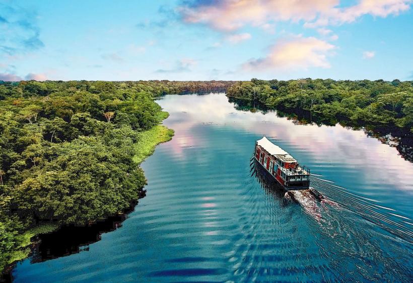
The reserve encompasses vast tracts of flooded forests (várzea) and terra firme forests. Water bodies, including rivers, lakes, and swamps, are prevalent, exhibiting varying shades of brown and black depending on sediment load and dissolved organic matter. Vegetation is dense, characterized by emergent trees, palms, and aquatic plants. Wildlife is abundant but often concealed within the foliage and waterways.
Location & Access Logistics
Pacaya-Samiria National Reserve is situated approximately 150 kilometers southwest of Iquitos, the capital of the Loreto Region. Access is primarily via river. From Iquitos, boat transport is required, typically a multi-day journey along the Marañón and Ucayali rivers, or their tributaries like the Pacaya and Samiria rivers. Smaller towns like Nauta serve as common departure points for organized tours. Road access to the reserve's periphery is limited and generally not suitable for standard vehicles. There are no designated parking areas within the reserve itself; boat operators manage vehicle parking at departure points.
Historical & Ecological Origin
The reserve was established on February 25, 1982, to protect a significant portion of the Amazon rainforest and its biodiversity. Ecologically, it is classified as a tropical rainforest ecosystem with extensive flooded forest areas, a critical habitat for numerous species adapted to seasonal inundation. The area is a vital watershed for the Marañón and Ucayali rivers.
Key Highlights & Activities
Activities include wildlife observation (pink river dolphins, manatees, various bird species, primates, reptiles), guided boat tours through waterways, piranha fishing (catch and release often practiced), jungle trekking on designated trails, and overnight stays in eco-lodges or camping. Birdwatching is a primary draw, with over 450 species recorded.
Infrastructure & Amenities
Within the reserve, infrastructure is minimal and focused on conservation and eco-tourism. Designated ranger stations provide basic facilities. Some eco-lodges offer lodging, meals, and guided services. Restrooms are available at lodges and ranger stations. Shade is abundant due to the dense forest canopy. Cell phone signal is generally absent within the core areas of the reserve; limited connectivity may be found in gateway towns like Nauta.
Best Time to Visit
The best time to visit is during the dry season, from June to November, when water levels are lower, exposing more land for trekking and making wildlife spotting easier along riverbanks. The wet season (December to May) sees higher water levels, facilitating deeper exploration by boat into flooded areas, which can be advantageous for observing aquatic life and certain bird species. There are no specific tide requirements as the reserve is freshwater.
Facts & Legends
The reserve is home to the legendary "Dorado," a mythical city of gold, which has fueled exploration and folklore for centuries. A specific tip for visitors is to be aware of the seasonal changes; the accessibility and visibility of certain areas and wildlife are directly influenced by the water levels.
Nearby Landmarks
- Nauta Town (0.5km West): Gateway town for river expeditions.
- Allpahuayo-Mishana National Reserve (80km North): Another significant protected area focused on biodiversity.
- Pacaya River (Adjacent): A primary waterway for accessing the reserve.
- Samiria River (Adjacent): Another key river system within the reserve.
- Iquitos City (150km Northeast): Major urban center and transportation hub.