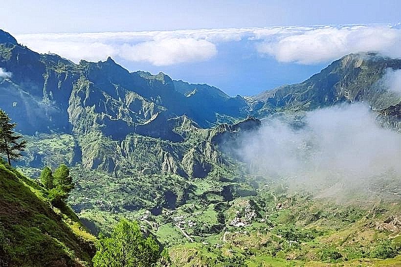
Landmark: Paúl Valley
City: Ribeira Grande
Country: Cabo Verde
Continent: Africa
Paúl Valley, Ribeira Grande, Cabo Verde, Africa
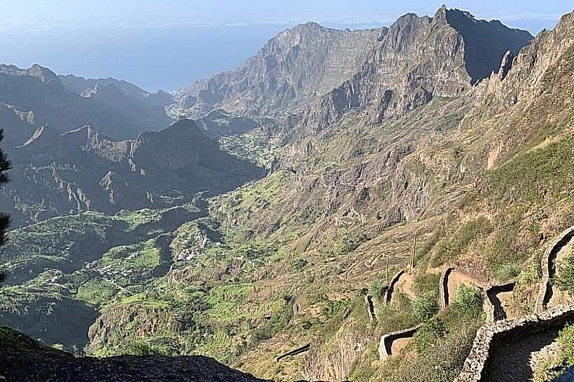
Paúl Valley is a geographical depression located on the island of Santo Antão, within the municipality of Ribeira Grande, Cabo Verde.
This valley is characterized by its steep, terraced slopes and a permanent watercourse.
Visual Characteristics
The valley walls are composed of dark volcanic rock, extensively modified by human cultivation into a series of distinct agricultural terraces. These terraces are predominantly green due to dense vegetation, including banana trees, sugarcane, and various fruit crops. The valley floor contains a seasonal riverbed, often dry during the dry season but carrying water after rainfall. The overall impression is one of intense agricultural activity carved into a rugged, mountainous landscape.
Location & Access Logistics
Paúl Valley is situated inland from the northern coast of Santo Antão. Access is primarily via the regional road EN1-SA01, which connects to the town of Ribeira Grande. From Ribeira Grande, local transport, typically shared taxis (alugueres) or private vehicles, can reach the valley. The drive from Ribeira Grande to the main access points within the valley is approximately 15 kilometers. Parking is limited and often informal along the roadside. Public transport within the valley itself is infrequent; alugueres operate on specific routes connecting villages.
Historical & Ecological Origin
The valley's current form is a result of centuries of human intervention. The terracing system, known as "socalcos," was developed by early settlers to maximize arable land on the steep slopes, a technique common in mountainous agricultural regions. Ecologically, the valley is a result of volcanic activity that formed the island, with subsequent erosion shaping the depression. The permanent watercourse is sustained by rainfall and springs originating in the higher elevations.
Key Highlights & Activities
Hiking is the primary activity, with trails traversing the terraced slopes and connecting the small hamlets within the valley. Specific trails include the route from Fontainhas to Cruzinha, which offers extensive views of the valley and coastline. Visiting local distilleries to observe the production of grogue (local rum) is possible. Observing the agricultural practices and the intricate terracing system is a key focus for visitors.
Infrastructure & Amenities
Basic amenities are available in the small villages scattered throughout the valley. These include small local restaurants (tascas) offering regional food. Restrooms are generally available at these establishments. Shade is provided by the dense vegetation and the overhang of the valley walls in certain areas. Cell phone signal can be intermittent, particularly in the deeper sections of the valley. There are no formal food vendors outside of the local tascas.
Best Time to Visit
The best time for visiting Paúl Valley is during the dry season, from November to June, when rainfall is minimal and hiking conditions are optimal. The mornings offer clearer light for photography of the terraced landscape. The valley is accessible year-round, but the greenest vegetation is typically observed after the rainy season.
Facts & Legends
A notable aspect of Paúl Valley is its role in the production of grogue, a potent distilled spirit made from sugarcane. Local families have been producing grogue using traditional methods for generations. A specific tip for visitors is to engage with local farmers; many are willing to explain their cultivation techniques and the history of the terracing.
Nearby Landmarks
- Cruzinha (0.8km West)
- Fontainhas (2.5km North)
- Ribeira Grande Town (15km East)
- Cova Crater (18km South)