Landmark: Pueblo de Boconó
City: Trujillo State
Country: Venezuela
Continent: South America
Pueblo de Boconó, Trujillo State, Venezuela, South America
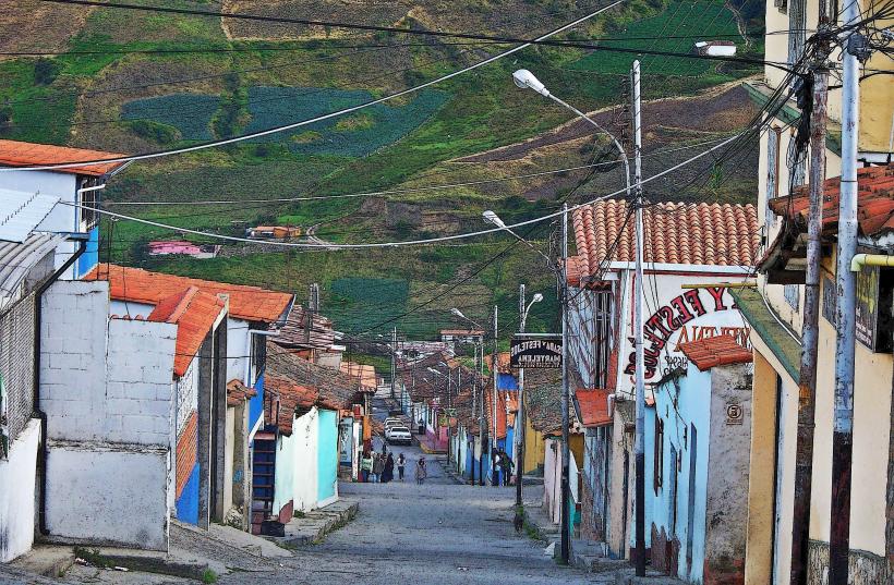
Pueblo de Boconó is a municipality located in the Trujillo State of Venezuela. It is situated in the Andes mountain range.
Visual Characteristics
The municipality is characterized by its mountainous terrain, with elevations ranging from approximately 1,000 to 2,500 meters above sea level. The landscape features steep slopes, valleys, and plateaus. Vegetation is predominantly Andean cloud forest, with dense foliage, including various species of trees, ferns, and orchids. The architecture in the main town of Boconó consists of colonial-style buildings with red-tiled roofs, whitewashed walls, and wooden balconies. The surrounding rural areas are marked by agricultural terraces and scattered farmhouses.
Location & Access Logistics
Pueblo de Boconó is located approximately 60 kilometers west of Trujillo City, the state capital. Access is primarily via the regional highway TR-10, which connects to the Pan-American Highway. The road is paved but can be winding due to the mountainous terrain. Driving time from Trujillo City is approximately 1.5 to 2 hours. There is limited public transportation; intercity buses operate between major cities and Boconó, but local transport within the municipality is scarce. Parking is available in designated areas within the town center, though it can be limited during peak times.
Historical & Ecological Origin
The area was originally inhabited by indigenous peoples before Spanish colonization. The town of Boconó was founded in 1660 by Captain Juan de Madrigal. Its historical purpose was as an agricultural and administrative center in the Andean region. Ecologically, the region is part of the Venezuelan Andes, characterized by its high altitude and specific microclimates supporting cloud forest ecosystems. The agricultural practices have shaped the landscape over centuries, with terracing being a notable feature.
Key Highlights & Activities
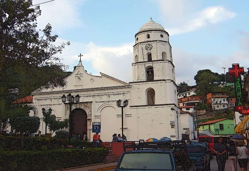
Hiking is possible on trails leading to viewpoints overlooking the valleys. Visiting the central plaza and the San Agustín Church in Boconó town is recommended. Exploring the local markets for regional produce and crafts is an option. Observing the cloud forest vegetation and birdlife is a primary activity for nature enthusiasts. Visits to nearby coffee plantations can be arranged.
Infrastructure & Amenities
Basic infrastructure is present in the town of Boconó, including a hospital, a police station, and a post office. Restrooms are available in public spaces and restaurants. Shade is provided by trees in plazas and covered market areas. Cell phone signal (2G/3G) is generally available in the town center but can be intermittent in more remote areas. Food vendors and small restaurants offering local cuisine are present in Boconó.
Best Time to Visit
The best months for visiting are generally from December to March, which constitute the dry season, offering clearer skies and less rainfall. The best time of day for photography is typically in the morning, between 8:00 AM and 10:00 AM, when the sunlight illuminates the valleys and mountains. Afternoon can bring cloud cover due to the altitude.
Facts & Legends
A local legend speaks of a hidden waterfall, known as "La Cascada Escondida," said to possess healing properties, though its exact location remains a subject of local folklore and is not officially mapped. The region is also known for its production of high-quality coffee.
Nearby Landmarks
- 0.5km North: San Agustín Church
- 2.0km East: Mirador de Boconó (Viewpoint)
- 5.0km Southwest: La Cascada de las Monjas (Waterfall)
- 10.0km West: Páramo de La Culata National Park entrance