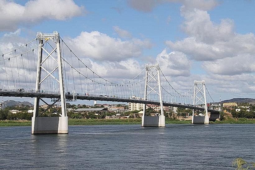
Landmark: Samora Machel Bridge
City: Tete
Country: Mozambique
Continent: Africa
Samora Machel Bridge, Tete, Mozambique, Africa
The Samora Machel Bridge is a road bridge spanning the Zambezi River in Tete, Mozambique.
It connects the city of Tete with the northern bank of the river, facilitating regional transport.
Visual Characteristics
The bridge is a steel truss structure with a total length of 1,004 meters. It features multiple concrete piers supporting the spans. The deck is asphalted and accommodates two lanes of vehicular traffic and a pedestrian walkway on one side. The color of the steel structure is a weathered grey, with visible rust in some areas. The piers are constructed from reinforced concrete.
Location & Access Logistics
The bridge is located approximately 3 kilometers west of the Tete city center. Access is via National Road N1, which crosses the bridge. Parking is available on both the Tete city side and the northern bank, though it is informal and can be congested. Public transport includes local minibuses (chapas) that regularly cross the bridge, serving routes within Tete and to surrounding areas. There are no specific bus lines designated solely for the bridge crossing.
Historical & Ecological Origin
Construction of the Samora Machel Bridge began in 1963 and was completed in 1965. It was designed by the Portuguese engineering firm Profabril. The bridge was originally named Ponte Dona Albertina, after the wife of the Portuguese Governor-General of Mozambique at the time. Its primary purpose was to improve transportation and trade links across the Zambezi River, which was a significant barrier to development in the region. The bridge's construction involved significant engineering to overcome the river's width and flow.
Key Highlights & Activities
Observation of the Zambezi River's flow and surrounding landscape from the pedestrian walkway. Photography of the bridge's engineering structure. Crossing the bridge by vehicle or on foot to access communities on the northern bank.
Infrastructure & Amenities
Restrooms are not directly available on the bridge itself but can be found in nearby service stations and businesses on either approach. Shade is minimal on the bridge, primarily provided by the structure itself during certain times of day. Cell phone signal (4G/5G) is generally available across the bridge, depending on the carrier. Food vendors are present in the immediate vicinity of the bridge approaches, particularly on the Tete city side.
Best Time to Visit
For photography of the bridge structure, early morning or late afternoon light provides optimal angles and reduces harsh shadows. The dry season, from May to October, offers more stable weather conditions and lower river levels, which can make the surrounding landscape more accessible. There are no tide-dependent activities related to the bridge itself.
Facts & Legends
During its construction, the bridge was considered a major engineering feat for its time, significantly reducing travel times and opening up previously isolated areas. A local anecdote suggests that during periods of exceptionally high flood, the Zambezi River has been known to reach the underside of the bridge deck, though this is rare.
Nearby Landmarks
- Tete Cathedral (0.8km South)
- Municipal Market of Tete (1.2km South)
- Fort São Tiago (1.5km South)
- Tete Provincial Government Building (1.8km South)