Landmark: Victory Hill
City: Rabaul
Country: Papua New Guinea
Continent: Australia
Victory Hill, Rabaul, Papua New Guinea, Australia
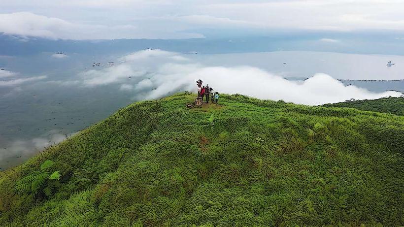
Victory Hill is a prominent volcanic cone located on the Gazelle Peninsula, near Rabaul, East New Britain Province, Papua New Guinea.
This geological feature offers panoramic views of Blanche Bay and the surrounding Rabaul caldera.
Visual Characteristics
Victory Hill is a steep, conical volcanic peak covered in dense tropical vegetation. Its slopes are primarily composed of dark volcanic soil and rock. The summit area is relatively clear, providing unobstructed sightlines.
Location & Access Logistics
Victory Hill is situated approximately 3 kilometers southwest of Rabaul's town center. Access is via the Rabaul-Kokopo Highway, turning onto a well-maintained gravel road leading to the base of the hill. Parking is available at the trailhead. Public transport options are limited; private vehicles or taxis are the most practical means of reaching the site.
Historical & Ecological Origin
Victory Hill is a stratovolcano, part of the Rabaul caldera complex, which is a large, active volcanic caldera. Its formation is a result of repeated volcanic eruptions over millennia. The hill gained its name during World War II, serving as a strategic observation point.
Key Highlights & Activities
Hiking to the summit is the primary activity. The trail is approximately 1.5 kilometers in length and moderately steep. Visitors can observe World War II relics, including remnants of defensive structures, along the ascent. Photography of the Rabaul caldera and Blanche Bay from the summit is a key highlight.
Infrastructure & Amenities
Basic amenities are limited. There are no permanent restroom facilities at the trailhead or summit. Shade is minimal along the trail and at the summit. Cell phone signal (4G/5G) is generally available but can be intermittent. No food vendors are present at the site; visitors should carry their own provisions.
Best Time to Visit
The best time of day for photography is in the morning, between 8:00 AM and 10:00 AM, when the sun illuminates Blanche Bay. The dry season, from June to September, offers the most favorable weather conditions with reduced rainfall. The hill is accessible year-round.
Facts & Legends
During the Japanese occupation in World War II, the hill was fortified and used as a command post. A specific point on the summit offers a clear view of the sunken Japanese warships in Blanche Bay, a testament to the naval battles of the era.
Nearby Landmarks
- Rabaul War Cemetery (1.2km Northeast)
- Rabaul Museum (3.5km Northeast)
- Bita Paka War Cemetery (10km Southeast)
- Tavui Peninsula (4km East)