City: Thika
Country: Kenya
Continent: Africa
Thika, Kenya, Africa
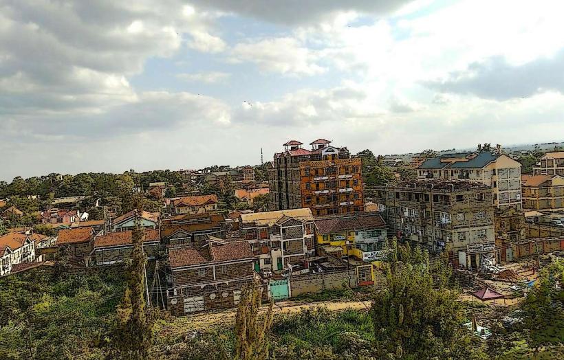
Thika is a major industrial and commercial center in Kiambu County, situated at an elevation of 1,631 meters. It is located approximately 42 kilometers northeast of Nairobi and serves as the primary gateway to the Central Highlands.
Historical Timeline
Thika originated as a resting point for travelers between Nairobi and the northern regions. Its name is derived from the Kikuyu word Guthika ("to bury") or the Maasai word Sika ("rubbing"). The primary event shaping its current urban form was the 1924 construction of the Blue Posts Hotel and the subsequent post-independence industrialization strategy that established it as the "Birmingham of Kenya." The 2012 completion of the Thika Superhighway transformed the town into a key satellite city for the Nairobi metropolitan area.
Demographics & Population
The estimated metropolitan population for 2026 is 315,000. The demographics are predominantly Kikuyu, with significant Kamba and Meru communities. The city has a high concentration of industrial workers and students from Mount Kenya University. The median age is approximately 20.5 years.
Urban Layout & Key Districts
The city is organized around the Thika Superhighway and the Thika-Garissa road.
CBD: A high-density commercial core characterized by retail outlets and banks.
Section 9 & Section 2: Affluent, low-density residential areas.
Makongeni: A sprawling residential and industrial district to the east.
Thika Greens: A modern, high-end gated community and golf estate on the outskirts.
Top City Landmarks
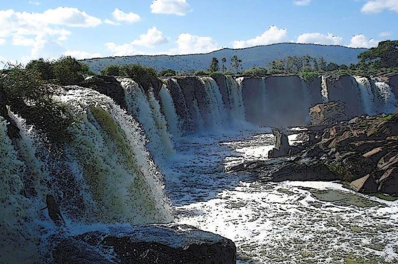
Chania Falls & Thika Falls: Two significant waterfalls located near the Blue Posts Hotel.
Fourteen Falls: A spectacular series of 14 waterfalls on the Athi River (22 km away).
Ol Donyo Sabuk National Park: A mountain park featuring the tomb of Lord Northrup McMillan.
Mugumo Garden: A historic site where a giant sacred fig tree once stood, linked to prophecies by Mugo wa Kibiru.
Mount Kenya University Main Campus: A dominant educational landmark.
Transportation Network
Intra-city transit is managed by Matatus, Boda Bodas, and Tuk-tuks. Thika is the terminus of the Thika Superhighway, providing rapid access to Nairobi. The Meter Gauge Railway (MGR) provides daily commuter services to Nairobi's central station. Traffic density is high within the CBD and at the junction of the Garissa Road.
Safety & "Red Zones"
The general safety level is moderate. Petty theft is common in the main bus park and the informal markets. Specific "red zones" include parts of Kiandutu and Witeithie after dark. Travelers should be cautious near the falls during the rainy season due to slippery rocks and rising water levels.
Digital & Financial Infrastructure
Internet speeds average 30–50 Mbps. Main carriers are Safaricom and Airtel. M-Pesa is the dominant payment method. ATMs are ubiquitous along Kenyatta Highway and within Ananas Mall and Juja City Mall. Credit card acceptance is limited to supermarkets and large hotels.
Climate & Air Quality
Temperatures range from 13°C to 28°C. The climate is temperate and subtropical. Air quality is moderate; while generally good, localized industrial emissions occur in the southern manufacturing zones. Significant weather risks include heavy hailstorms during the rainy seasons.
Culture & Social Norms
English, Swahili, and Gikuyu are the primary languages. Thika is an industrial hub with a strong "working class" identity, balanced by a growing "commuter" population that works in Nairobi. Tipping is standard at 5–10% in restaurants. Shaking hands is the standard greeting.
Accommodation Zones
Section 9: Recommended for quiet, mid-range hotels and safety.
Nyeri Road (Near Blue Posts): Recommended for greenery, historical sites, and waterfall access.
Local Cost Index
1 Espresso: 250 KES ($1.60 USD)
1 Standard Lunch (Nyama Choma/Ugali): 700 KES ($4.50 USD)
1 Short Boda Boda Trip: 100 KES ($0.65 USD)
Nearby Day Trips
Kilimambogo: 25 km (Hiking and views).
Masinga Dam: 60 km (Hydroelectric dam and water sports).
Yatta Plateau: 30 km (The world’s longest lava flow).
Facts & Legends
Thika was made globally famous by Elspeth Huxley’s 1959 book, The Flame Trees of Thika. A local legend involves the sacred Mugumo tree; it was prophesied that when the tree fell, colonial rule would end. In 1963, despite efforts by colonial engineers to reinforce it with iron hoops, the tree died and split, coinciding with Kenya's independence. A verified historical oddity is that Thika is home to several major multi-national fruit processing plants, making it a primary global source for canned pineapple.