Landmark: Agate Bay
City: Two Harbors
Country: USA Minnesota
Continent: North America
Agate Bay, Two Harbors, USA Minnesota, North America
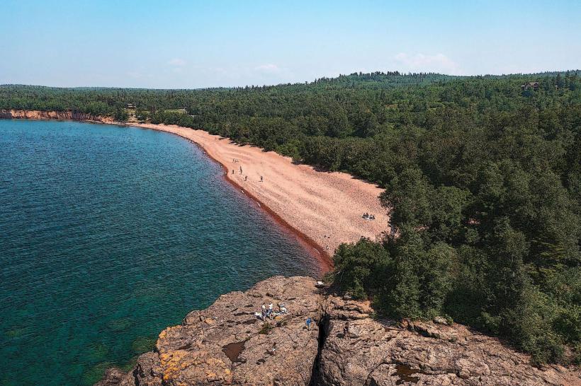
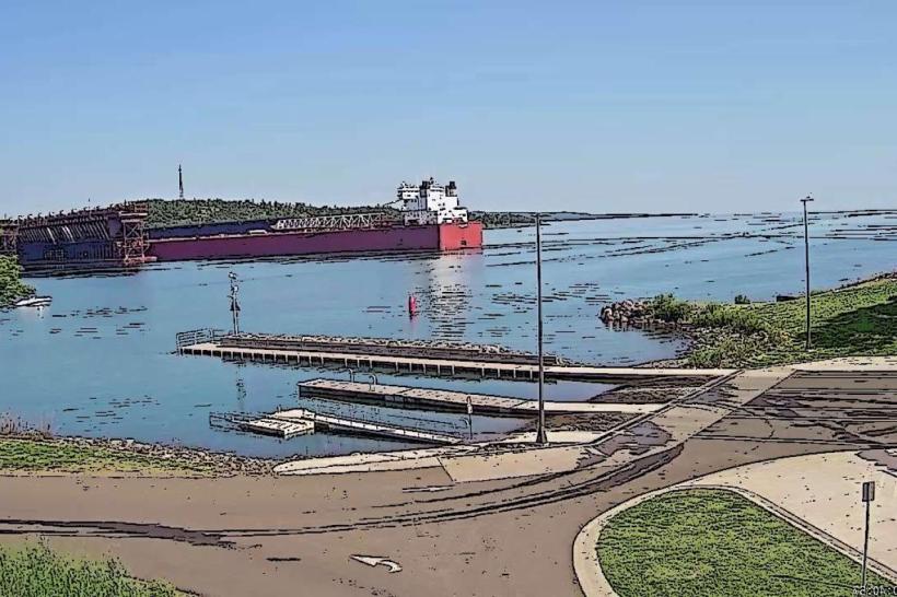
Agate Bay is a natural harbor located in Two Harbors, Minnesota, on the western shore of Lake Superior.
It serves as a significant port and recreational area.
Visual Characteristics
The bay is characterized by its deep, clear water, typically exhibiting shades of blue and green depending on light conditions. The shoreline is composed of a mix of smooth, rounded stones, primarily agates, and gravel. The bay is partially enclosed by a breakwater constructed of large, dark gray rock. Surrounding vegetation consists of coniferous trees, predominantly pine and spruce, with some deciduous species closer to the shore.
Location & Access Logistics
Agate Bay is situated at the eastern edge of Two Harbors, Minnesota. Access is directly from State Highway 61. The bay is approximately 0.5km East of the Two Harbors city center. Ample parking is available at the public boat launch and adjacent to the breakwater. Public transport options are limited; the closest bus stop is located on Waterfront Drive, approximately 0.8km West of the bay.
Historical & Ecological Origin
Agate Bay is a natural indentation of the Lake Superior coastline, shaped by glacial activity and subsequent erosion. The bay's name derives from the abundance of agates found along its shores, a result of the geological composition of the region. The breakwater was constructed in the early 20th century to provide shelter for shipping and was built using locally sourced stone.
Key Highlights & Activities
Visitors can walk along the breakwater for views of Lake Superior and the Duluth-Superior harbor entrance. Rock collecting, specifically searching for agates, is a primary activity. Kayaking and paddleboarding are possible within the sheltered waters of the bay. Fishing from the shore or breakwater is permitted.
Infrastructure & Amenities
Restrooms are available at the public boat launch facility. Limited shade is provided by surrounding trees. Cell phone signal (4G/5G) is generally reliable within the bay area. Food vendors are not present directly at the bay; dining options are available in the nearby Two Harbors city center.
Best Time to Visit
For photography, early morning or late afternoon light offers optimal conditions for capturing the bay's colors. The best months for visiting are from June to September, offering milder weather. High tide is not a significant factor for access or activities within the bay.
Facts & Legends
A local legend suggests that the most perfect agates are found after a strong storm on Lake Superior, as the waves churn the lakebed and deposit them along the shore. The breakwater is also known for its role in protecting the town's harbor during severe weather events.
Nearby Landmarks
- Two Harbors Lighthouse (0.3km West)
- Gooseberry Falls State Park (16km Northeast)
- Split Rock Lighthouse State Park (25km Northeast)
- Palisade Head (28km Northeast)