Landmark: Gooseberry Falls State Park
City: Two Harbors
Country: USA Minnesota
Continent: North America
Gooseberry Falls State Park, Two Harbors, USA Minnesota, North America
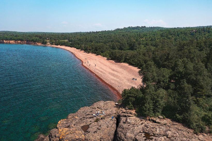
Gooseberry Falls State Park is a protected natural area located on the North Shore of Lake Superior near Two Harbors, Minnesota.
The park encompasses approximately 40 miles of hiking trails and features a series of waterfalls along the Gooseberry River.
Visual Characteristics
The park's landscape is characterized by mixed coniferous and deciduous forests, with granite outcrops and the clear, cold waters of Lake Superior. The Gooseberry River cascades over multiple tiers of basalt rock formations, creating distinct waterfalls. The riverbed consists of smooth, rounded stones and bedrock. Vegetation includes pine, spruce, birch, and aspen trees, with a dense undergrowth of ferns and mosses.
Location & Access Logistics
Gooseberry Falls State Park is situated 13 miles northeast of Two Harbors, Minnesota, directly off State Highway 61. The park entrance is clearly marked from the highway. Ample parking is available at the main visitor center and at designated trailheads throughout the park. Public transportation is not available to the park.
Historical & Ecological Origin
The park was established in 1937. The waterfalls are a result of the Gooseberry River carving through ancient lava flows that form the bedrock of the region. The area's geological history is tied to the Midcontinent Rift System, which occurred approximately 1.1 billion years ago. The park protects a portion of the Lake Superior watershed, an important ecosystem for native fish and migratory birds.
Key Highlights & Activities
Hiking is a primary activity, with trails leading to the Upper, Middle, and Lower Falls of the Gooseberry River. The paved path to the Lower Falls is accessible. Photography of the waterfalls is popular. Fishing is permitted in designated areas of the river and Lake Superior. Picnicking is available at several designated sites. Winter activities include cross-country skiing and snowshoeing on groomed trails.
Infrastructure & Amenities
Restrooms are available at the visitor center and at various points within the park. Sheltered picnic areas are provided. Cell phone signal (4G/5G) is generally available within the park, particularly near the visitor center. There are no on-site food vendors, but Two Harbors offers dining options approximately 13 miles to the southwest.
Best Time to Visit
For waterfall viewing, spring (April-May) offers the highest water flow due to snowmelt. Summer (June-August) provides pleasant weather for hiking and outdoor activities. Autumn (September-October) offers fall foliage. The best time of day for photography is typically mid-morning or late afternoon to avoid harsh midday light. High tide is not a relevant factor for accessing the waterfalls.
Facts & Legends
A local legend suggests that the smooth, rounded stones found along the riverbed are the petrified tears of a Native American maiden mourning her lost love. Geologically, these stones are the result of glacial action and the river's constant erosion of the basalt bedrock.
Nearby Landmarks
- Split Rock Lighthouse State Park (3.5km Southwest)
- Silver Creek Tunnel (6.2km Southwest)
- Tettegouche State Park (12.1km Northeast)
- Palisade Head (14.8km Southwest)
- Gooseberry Falls State Park Visitor Center (0.2km West)