Landmark: Belogradchik Fortress
City: Pleven
Country: Bulgaria
Continent: Europe
Belogradchik Fortress, Pleven, Bulgaria, Europe
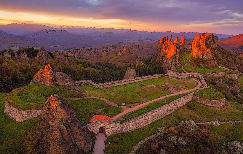
Belogradchik Fortress, also known as Kaleto, is a medieval stronghold integrated into a massive complex of sandstone and conglomerate rock formations. It is located on the northern slopes of the Balkan Mountains, adjacent to the town of Belogradchik, approximately 145 km northwest of Pleven.
Visual Characteristics
The fortress is defined by its use of natural rock pillars, some reaching 200 meters in height, as defensive walls. Man-made stone masonry, 2 to 2.5 meters thick, connects these formations to create three distinct fortified yards. The walls are constructed from red sandstone and limestone, featuring white mortar and brick decorative elements. The structure includes battlements, embrasures for cannons, and two main gates-the Vidin Gate and the Nish Gate-built in an Ottoman architectural style with vaulted ceilings and heavy iron-studded doors.
Location & Access Logistics
Access the site from Pleven via Road 11 or Road 13, heading west toward Montana and then following Road 102 to Belogradchik. The drive takes approximately 2 hours and 15 minutes. Upon entering the town of Belogradchik, asphalt roads lead directly to the fortress entrance at the highest point of the town. A paved parking area is available at the gate. Regional buses connect Sofia and Vidin to Belogradchik, while the nearest railway station is 12 km away in the village of Oreshets.
Historical & Ecological Origin
The fortress was originally established by the Romans in the 1st–3rd centuries AD to monitor the road from Ratiaria. In the 14th century, Bulgarian Tsar Ivan Stratsimir expanded the site, adding the upper citadel. The current appearance dates primarily to an 1837 reconstruction by the Ottoman Turks, who utilized French and Italian engineers. The surrounding Belogradchik Rocks are a natural phenomenon of Triassic sandstone, shaped by over 200 million years of erosion and tectonic activity.
Key Highlights & Activities
Visitors can climb the metal and stone staircases to the highest point of the citadel, known as the First Yard, for a 360-degree view of the Balkan Mountains. Exploration of the underground bunkers, grain silos, and the ammunition depot is possible. Numerous hiking trails originate at the fortress, weaving through the geological formations like "The Madonna" and "The Horseman." Photography is a primary activity due to the unique contrast between the red rocks and gray stone masonry.
Infrastructure & Amenities
The site features a ticket office, a small museum shop, and informational signage in multiple languages. Public restrooms are located near the parking area at the entrance. 5G and 4G cellular signals are stable throughout the complex. While the lower yards offer some shade from trees, the upper citadel is fully exposed. Food vendors and restaurants are located within 300 meters in the town of Belogradchik.
Best Time to Visit
The best time for photography is at sunset, as the red sandstone glows intensely under warm light. The optimal months are May through October. During winter, the stairs and rock paths can become extremely slippery due to ice and snow, requiring cautious navigation. The fortress is open daily, with extended hours during the summer season.
Facts & Legends
The fortress has never been taken by force; it was surrendered only through diplomatic means or during the cessation of hostilities. A local legend tells of a beautiful nun named Vitinya who was walled into the rocks as punishment for a forbidden love, and it is said that her silhouette can be seen among the stones, specifically the formation known as "The Madonna."
Nearby Landmarks
Magura Cave – 25km Northwest
Belogradchik Astronomical Observatory – 0.5km East
Historical Museum Belogradchik – 0.8km South
Borov Kamak Waterfall – 35km Southeast
Baba Vida Fortress (Vidin) – 52km North