Landmark: Blankenese
City: Hamburg
Country: Germany
Continent: Europe
Blankenese, Hamburg, Germany, Europe
Blankenese is a former fishing village turned affluent residential district in the Altona borough of Hamburg, situated on the high northern bank of the Elbe River.
Visual Characteristics
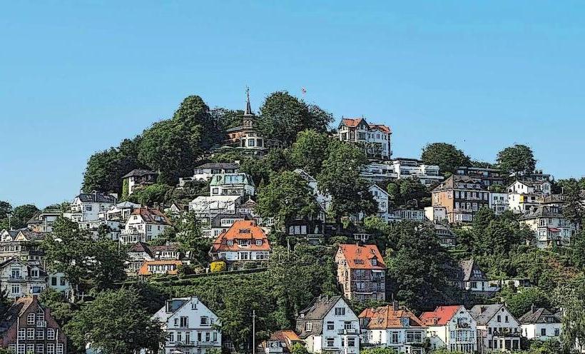
The area is defined by the Treppenviertel (Staircase Quarter), a car-free zone of white villas and historic fishermen's cottages built into the steep slopes of the Süllberg and Waseberg hills. It features narrow winding alleys and approximately 5,000 stairs. The architecture is a mix of traditional thatched-roof houses and sprawling 19th-century mansions. The waterfront is characterized by a sandy beach and views of the massive container ships entering Hamburg Harbor.
Location & Access Logistics
Located approximately 10km west of Hamburg city center (Postcode 22587).
Public Transit: Take the S1 or S11 S-Bahn line to Blankenese station.
The "Bergziege" (Mountain Goat): Small public bus lines (48 and 498) specifically designed to navigate the extremely narrow, steep streets.
Ferry: HADAG Ferry Line 62 (from Landungsbrücken to Finkenwerder) connects to Line 64 to reach the Blankenese pier.
Parking: Extremely difficult in the lower quarter; use the "Parkhaus am Bahnhof" and walk down.
Historical & Ecological Origin
Originally a Danish fishing and pilots' village, it was annexed by Prussia in 1866 and incorporated into Altona in 1927. The name "Blankenese" refers to the "white nose" (low German: blanke neese), a white sand headland that was washed away in a storm surge in 1634. The area includes the Falkenstein nature reserve and high dunes, forming part of the Elbe's glacial valley margin.
Key Highlights & Activities
Süllberg: A 75-meter-high hill offering panoramic views of the Elbe, the Airbus factory across the water, and the "Altes Land" fruit-growing region.
Elbe Beach: A popular destination for walking and watching ship traffic.
Hirschpark: A historic park featuring a deer enclosure and an ancient lime tree avenue.
Falkenstein Lighthouse: Located at the western edge near the beach.
Infrastructure & Amenities
The district center near the S-Bahn station features high-end boutiques, cafes, and a traditional weekly market. Several upscale restaurants and hotels are located on the Süllberg. Public restrooms are located at the train station and near the ferry pier. The Treppenviertel is not wheelchair accessible due to the thousands of steps, though the waterfront and main village center are level. 5G signal is consistent throughout.
Best Time to Visit
Spring and summer are optimal for the blooming gardens in the Treppenviertel. Sunset provides the best lighting for views from the Süllberg. Weekends are highly congested; weekday mornings offer a more authentic atmosphere.
Facts & Legends
A geographical oddity is the Waseberg, which has a gradient of up to 15%, making it one of the most difficult climbs in professional cycling (featured in the Cyclassics race). Legend states that the "Blankenese Pilots" were the most skilled on the Elbe, capable of navigating the shifting sands of the riverbed solely by the color of the water.
Nearby Landmarks
Airbus Factory (Finkenwerder) – Visible across the river
Jenisch Park – 4km East
Loki-Schmidt-Garten (Botanical Garden) – 3km East
Wittenbergen Nature Reserve – 2.5km West