Information
Landmark: Cascada de la GataCity: San Luis
Country: Argentina
Continent: South America
Cascada de la Gata, San Luis, Argentina, South America
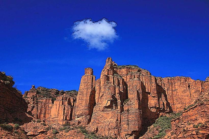
Cascada de la Gata is a waterfall located in the province of San Luis, Argentina. It is situated within the Sierras de las Quijadas National Park.
Visual Characteristics
The waterfall descends over a series of rock ledges, creating multiple tiers. The water is typically clear, with a light greenish hue depending on mineral content and light conditions. The surrounding rock formations are primarily sedimentary, exhibiting layered textures and varying shades of ochre and grey. Vegetation consists of low-lying scrub and hardy grasses adapted to arid conditions.
Location & Access Logistics
Cascada de la Gata is located approximately 15 kilometers west of the park's main entrance. Access is via unpaved park roads, requiring a vehicle with adequate ground clearance. The final approach involves a short hike of approximately 500 meters from the designated parking area. No public transport services operate directly to the waterfall.
Historical & Ecological Origin
The waterfall is a result of erosion acting upon the sedimentary rock layers of the Sierras de las Quijadas. The geological formations in the park date back to the Cretaceous period. The area is classified as a Monte de Sierras y Bolsones biogeographic district, characterized by arid and semi-arid conditions.
Key Highlights & Activities
Observation of the waterfall's descent. Photography of the rock formations and water flow. Hiking on designated trails within the park. Birdwatching for local avian species.
Infrastructure & Amenities
A designated parking area is available. No restrooms or food vendors are present at the immediate site of the waterfall. Cell phone signal is unreliable within the park boundaries.
Best Time to Visit
The best time for photography is during the morning or late afternoon when the sun angle provides optimal lighting on the rock faces. The months of April to October generally offer more pleasant temperatures for outdoor activities. Water flow is typically highest after seasonal rains, which occur primarily in summer (December-February).
Facts & Legends
Local folklore suggests the name "Cascada de la Gata" (Cat Waterfall) originates from the sound of the water resembling a cat's meow when flowing over certain rock formations. The park itself is known for its paleontological significance, with numerous dinosaur fossil discoveries.
Nearby Landmarks
- Parque Nacional Sierras de las Quijadas (Park Entrance) - 15km East
- Cerro El Toba - 8km Northeast
- Quebrada de los Cóndores - 12km Southeast
- Mirador del Sol - 10km South