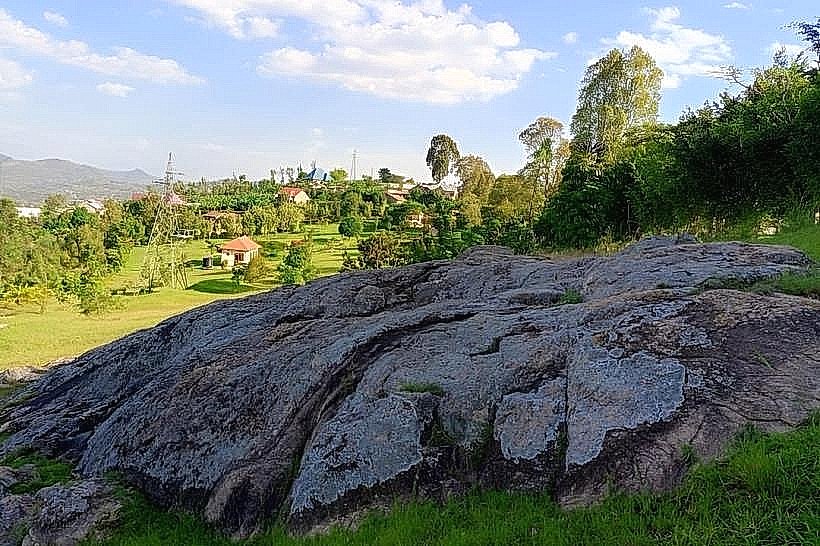
Landmark: Kamegeri Rock
City: Muhanga
Country: Rwanda
Continent: Africa
Kamegeri Rock, Muhanga, Rwanda, Africa
Kamegeri Rock, known locally as Urutare rwa Kamegeri, is a large granite geological formation located in the Ruhango District of the Southern Province, Rwanda. It is situated on a prominent hillside overlooking the surrounding agricultural valleys between the towns of Ruhango and Huye.
Visual Characteristics
The landmark is a massive, singular grey granite boulder with a distinctive flat upper surface and weathered, vertical fissures. The rock face is characterized by natural oxidation streaks in shades of rust and dark charcoal, with patches of hardy lichen and moss adhering to the shadowed crevices. The surrounding terrain consists of red latosol earth, terraced hillsides planted with cassava and maize, and scattered eucalyptus trees.
Location & Access Logistics
The site is located approximately 7km south of Ruhango town center and is accessed via a short, unpaved track branching off the main RN1 highway (Kigali-Huye Road). It is situated 35km north of Huye and roughly 80km southwest of Kigali. Visitors can reach the base of the hill via motorcycle taxi from the Ruhango bus terminal, followed by a steep 15-minute uphill walk on a dirt path. A small, informal clearing at the foot of the hill serves as a parking area for private vehicles.
Historical & Ecological Origin
The formation is a plutonic igneous rock outcropping created by volcanic activity and subsequent erosion within the Rwanda-Burundi basement complex millions of years ago. Historically, it is associated with the 18th-century reign of King Yuhi IV Gahindiro. According to oral tradition, the rock was the site of an execution involving a chief named Kamegeri, who had suggested the rock be heated to punish criminals, only to be cast onto it himself by royal decree.
Key Highlights & Activities
The flat summit of the rock serves as a natural observation platform, offering 360-degree views of the Southern Province highlands. Guided storytelling sessions by local community members provide detailed accounts of the monarchical history associated with the site. The surrounding slopes are used for light hiking and photography of the rural Rwandan landscape.
Infrastructure & Amenities
Infrastructure at the site is minimal, consisting of a basic stone stairway leading to the main viewing area. There are no public restrooms or permanent visitor centers on the immediate grounds. Shade is limited to the underside of the rock's overhangs and a few nearby trees. Mobile network coverage (4G) is strong due to the elevated position and proximity to the RN1 corridor. Bottled water and snacks are available at the small trading centers located 1km away on the main road.
Best Time to Visit
The site is open for visitation during daylight hours, typically 07:00 to 18:00. For optimal photography of the rock's texture and the valley views, visit between 08:00 and 10:30 or 16:00 and 17:30. The dry seasons from June to August and December to February are recommended to ensure the unpaved access path remains stable and non-slippery.
Facts & Legends
A verified historical oddity of Kamegeri Rock is that despite its exposure to the elements, the surface often retains significant thermal heat long after sunset, which locals attribute to the legendary fires once built upon it. A "secret" tip for visitors is to locate the small depressions in the granite near the eastern edge, which are traditionally said to be the permanent marks left by the intensive heating mentioned in the oral histories.
Nearby Landmarks
Ruhango District Office – 6.8km North
RN1 Highway Junction – 1.2km West
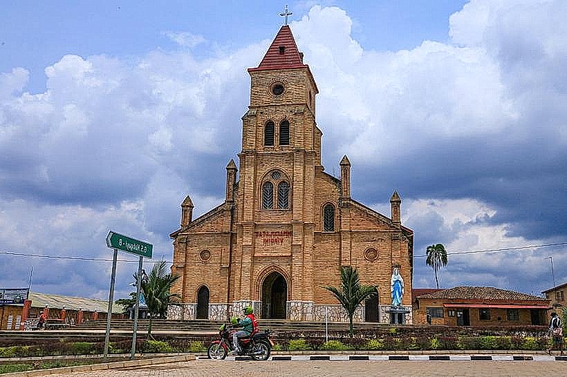
Kabgayi Catholic Cathedral – 18km North
Huye City Center – 35km South
Ruhango Market – 7.2km North