
Landmark: Mulindi National Liberation Museum
City: Gicumbi
Country: Rwanda
Continent: Africa
Mulindi National Liberation Museum, Gicumbi, Rwanda, Africa
The Mulindi National Liberation Museum, also known as the Umulindi w’Intwari, is a historical site located in the Mulindi sector of Gicumbi District in Northern Province, Rwanda. It marks the location of the former headquarters of the Rwanda Patriotic Front (RPF) and its armed wing during the 1990–1994 liberation struggle.
Visual Characteristics
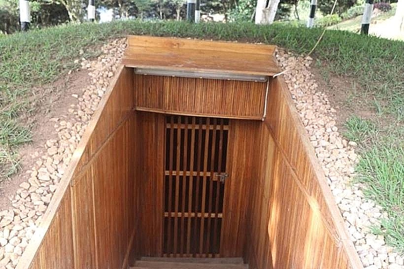
The museum is centered around a series of reinforced underground bunkers, or "dugouts," constructed with concrete, timber, and earth mounds for camouflage. The primary command bunker features narrow entryways and low ceilings, while the above-ground structures consist of modest brick and iron-roofed buildings formerly used as administrative offices. The surrounding landscape is characterized by high-altitude tea plantations, steep grassy ridges, and eucalyptus groves. The terrain is frequently shrouded in mist, reflecting the cool, humid climate of the northern highlands.
Location & Access Logistics
The site is located approximately 75km north of Kigali via the RN3 and RN30 highways. Access requires a 15km drive on a winding, partially unpaved road branching off from the main Kigali-Gatuna road at the Kaniga junction. Public transport is available via minibuses from the Nyabugogo terminal to Gicumbi, followed by a motorcycle taxi ("motto") to the museum gates. A designated gravel parking area is situated at the base of the command hill for private vehicles and tour buses.
Historical & Ecological Origin
The site served as the strategic and political headquarters for the RPF leadership from 1992 to 1994. The bunkers were manually excavated by soldiers to protect the high command from aerial bombardment and artillery fire. Geologically, Mulindi sits on the volcanic-residual soils of the Congo-Nile Divide at an elevation of approximately 2,100 meters. The area is ecologically part of the Rwandan montane ecosystem, characterized by high rainfall and fertile land suitable for tea cultivation.
Key Highlights & Activities
Guided tours provide access to the underground bunker where the current President of Rwanda resided during the conflict. Visitors can inspect the original radio transmission equipment used by Radio Muhabura and view the tactical maps and logistics centers preserved in their original state. The site also includes the "Football Pitch of Peace," where historic matches were played during ceasefire periods. Hiking trails lead from the bunkers through the adjacent tea estates to panoramic viewpoints of the Ugandan border.
Infrastructure & Amenities
The facility includes a modern visitor reception center with a small ticketing office and a photographic gallery. Public restrooms are located near the entrance gate. Shade is abundant within the bunker systems and under the broad eaves of the restored administrative buildings. Mobile network coverage is stable with 4G signals available, though 5G is intermittent due to the mountainous topography. There are no large-scale food vendors on-site, though small retail kiosks operate in the nearby Mulindi trading center.
Best Time to Visit
The museum is open daily from 08:00 to 17:00, including weekends and public holidays. For photography of the bunkers and the surrounding tea plantations, the hours between 09:00 and 11:00 offer the clearest light before the typical afternoon cloud cover. The dry seasons from June to August and December to February are optimal for navigating the unpaved access roads and hiking the exterior trails.
Facts & Legends
A verified historical oddity of the site is that the bunkers were designed to be completely invisible from the air, utilizing the natural slope of the hill and specific vegetation planting to evade detection by reconnaissance flights. A local point of interest is the "Commanders' Tree," a large eucalyptus where high-level strategic meetings were reportedly held in the open air to avoid electronic surveillance inside the buildings.
Nearby Landmarks
Mulindi Tea Factory – 1.5km South
Gatuna Border Post – 18km North
Gicumbi Town Center – 22km Southwest
Kaniga Trading Center – 12km West
Lake Bunyonyi (Uganda) – 25km Northwest