Landmark: Quais de la Loire
City: Angers
Country: France
Continent: Europe
Quais de la Loire, Angers, France, Europe
The Quais de la Loire in the context of Angers specifically refers to the developed riverfront area along the Maine River, which is the short tributary (approx. 12km) that connects the city to the Loire River. This area serves as a primary ecological and recreational corridor, linking the historic center with the surrounding Val de Loire landscape.
Visual Characteristics
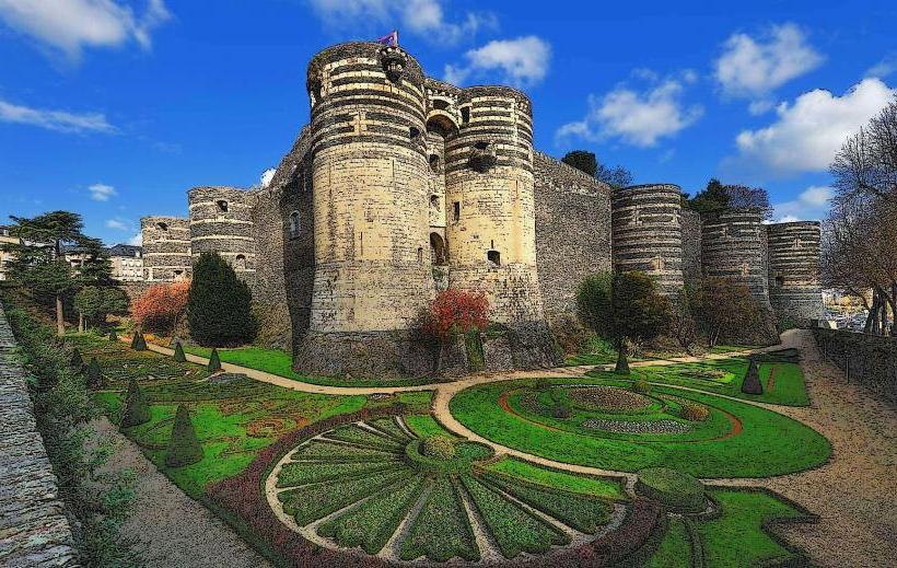
The riverfront is characterized by a contrast between the eastern bank (Rive Droite), featuring modern promenades and the imposing schist walls of the Château d’Angers, and the western bank (Rive Gauche/La Doutre), defined by older stone wharves and traditional slate-roofed houses. The landscape includes paved cycling paths, wooden pontoons for river shuttles, and expansive green spaces like the Cale de la Savatte.
Location & Access Logistics
The quays are located in the immediate center of Angers, stretching approximately 2km from the Pont de Verdun to the Pont de la Basse-Chaîne. It is a 10-minute walk (0.8km) north from the Angers Saint-Laud Train Station. The Irigo tramway (Line A) serves the area at the "Molière" stop. Dedicated cycling infrastructure connects the quays to the Loire à Vélo regional trail. Public parking is available at the Parking de la Poissonnerie or Parking Quai de la Maine.
Historical & Ecological Origin
Historically, the quays were the commercial heart of Angers, used for the transport of slate (ardoise), tuffeau stone, and wine. In the 20th century, a highway (voie sur berge) separated the city from the water; however, the "Angers Cœur de Maine" project has recently reclaimed this space, burying sections of the road to create a unified pedestrian plaza. Ecologically, the area is part of the Basses Vallées Angevines, a Natura 2000 protected zone known for its seasonal flooding and migratory bird populations.
Key Highlights & Activities
Activities center around the Cale de la Savatte, which hosts the Théâtre le Quai and the docking points for river cruises and electric boat rentals. The Guinguette du Héron Carré (a seasonal open-air cafe) is a major social hub on the western bank. The quays are a primary section of the Loire à Vélo cycling route, attracting thousands of cycle tourists annually.
Infrastructure & Amenities
The riverfront features public Wi-Fi zones, modern benches with integrated USB charging ports near the Esplanade Cœur de Maine, and several public restrooms. 5G cellular signal is excellent along the entire river corridor. The paths are designed for universal accessibility, featuring gentle gradients and smooth surfaces suitable for wheelchairs and strollers.
Best Time to Visit
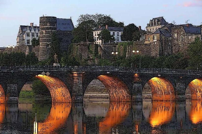
Sunset is the optimal time for photography, as the light reflects off the Maine and illuminates the towers of the Château d'Angers. The area is most vibrant during the Accroche-Cœurs street theater festival in September and on Sunday afternoons throughout the summer.
Facts & Legends
A verified historical oddity is that while the quays are associated with the Loire, the river flowing through them-the Maine-is one of the shortest rivers in France, formed by the confluence of the Mayenne, Sarthe, and Loir rivers just north of the city. Local lore suggests that the "Marine de Loire" sailors who frequented these quays had a distinct dialect and social hierarchy that set them apart from the inland "Angerins" for centuries.
Nearby Landmarks
Château d'Angers: 0.1km East
Théâtre Le Quai: 0.1km West
Cathédrale Saint-Maurice: 0.3km East
Musée Jean-Lurçat: 1.0km North
Parc Balzac: 0.8km Southwest