Landmark: Runit Dome
City: Enewetak Atoll
Country: Marshall Islands
Continent: Australia
Runit Dome, Enewetak Atoll, Marshall Islands, Australia
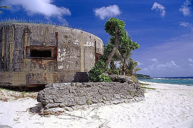
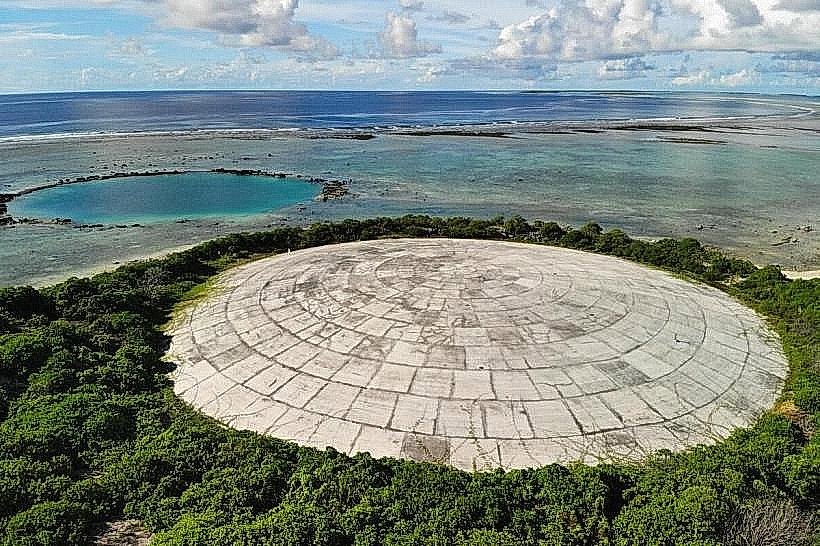
Runit Dome is a concrete structure located on Enewetak Atoll in the Marshall Islands. It serves as a cap for radioactive waste.
Visual Characteristics
The structure is a circular concrete dome, approximately 18 meters in diameter and 7 meters high. Its surface is weathered concrete, showing signs of age and exposure to the elements. The dome is situated on a coral island, surrounded by vegetation and the Pacific Ocean.
Location & Access Logistics
Runit Dome is located on Runit Island, one of the 40 islands comprising Enewetak Atoll. Access to Enewetak Atoll is primarily via charter aircraft to Enewetak Airfield (ENT). From the main island of Enewetak, Runit Island is accessible by boat. There are no public transport services to Runit Dome. Visitors require specific permits and arrangements through the local authorities or designated tour operators.
Historical & Ecological Origin
Runit Dome was constructed between 1977 and 1980 by the United States Department of Energy. Its purpose was to contain approximately 85,000 cubic meters of radioactive contaminated soil and debris resulting from nuclear weapons testing conducted on Enewetak Atoll between 1946 and 1958. The waste was consolidated and covered with the concrete dome.
Key Highlights & Activities
Observation of the Runit Dome structure from a safe distance. Educational tours focusing on the history of nuclear testing and the environmental remediation efforts. Photography of the dome and its surrounding landscape.
Infrastructure & Amenities
There are no public amenities directly at Runit Dome. Basic facilities such as restrooms and shade are not available. Cell phone signal is unreliable. Food vendors are not present on Runit Island; visitors must bring their own provisions.
Best Time to Visit
The best time to visit Enewetak Atoll, and by extension Runit Dome, is during the dry season, which generally runs from January to April. This period offers the most favorable weather conditions with less rainfall. Access is dependent on sea conditions, which can be rough outside of calmer periods.
Facts & Legends
A unique aspect of Runit Dome is that the concrete used in its construction incorporated radioactive materials from the testing sites, effectively making the dome itself a repository of some of the contamination it was designed to contain. Local accounts sometimes refer to the dome as the "Tomb of the Nuclear Dead."
Nearby Landmarks
- Enewetak Atoll Local Government Office (1.5km Southwest)
- Enewetak Airfield (ENT) (2.0km West)
- Enjebi Island (4.0km North)
- Ujelang Atoll (4.8km Southeast)