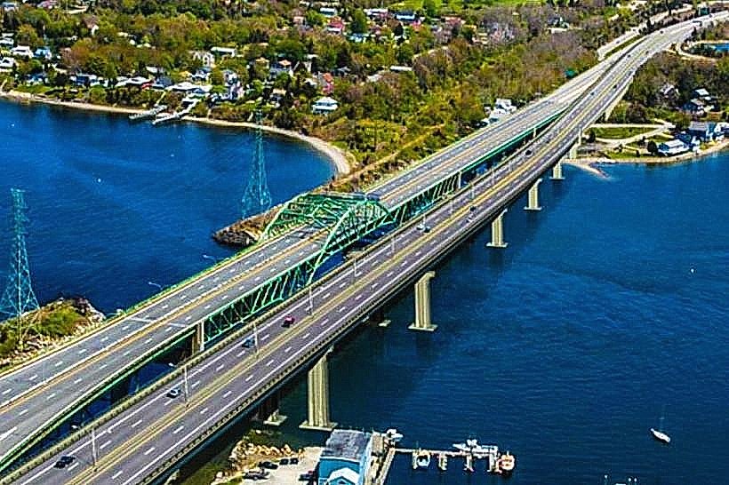
Landmark: Sakonnet River Bridge
City: Portsmouth RI
Country: USA Rhode Island
Continent: North America
Sakonnet River Bridge, Portsmouth RI, USA Rhode Island, North America
The Sakonnet River Bridge is a vehicular bridge spanning the Sakonnet River, connecting the towns of Portsmouth and Tiverton in Rhode Island, USA.
This bridge serves as a critical transportation link across the river, facilitating travel between Aquidneck Island and the mainland.
Visual Characteristics
The bridge is a steel truss structure with a deck carrying four lanes of traffic. Its primary color is a utilitarian gray, with concrete abutments and steel support elements. The deck is approximately 1,000 feet (305 meters) long and 60 feet (18 meters) wide. The clearance beneath the bridge for marine traffic is approximately 50 feet (15 meters) at mean high water.
Location & Access Logistics
The Sakonnet River Bridge is located approximately 5 miles (8 kilometers) east of downtown Portsmouth, Rhode Island. Access is directly from RI Route 24, which merges with RI Route 138. There are no dedicated public parking facilities at the bridge itself. The nearest public transportation is the RIPTA bus route 60, which stops at the intersection of RI Route 138 and East Main Road in Tiverton, approximately 1 mile (1.6 kilometers) from the eastern approach.
Historical & Ecological Origin
The current Sakonnet River Bridge was completed in 2012, replacing an older structure built in 1956. The original bridge was a bascule bridge, designed to lift for marine traffic. The replacement was constructed to improve structural integrity and traffic flow. The river itself is an estuary, part of the Narragansett Bay watershed, characterized by tidal flows and brackish water.
Key Highlights & Activities
The primary function of the Sakonnet River Bridge is vehicular transit. Pedestrian and bicycle access is not permitted on the bridge itself. Observation of marine traffic passing beneath the bridge is possible from nearby shorelines.
Infrastructure & Amenities
There are no restrooms, shade structures, or food vendors directly at the bridge. Cell phone signal (4G/5G) is generally available across the bridge.
Best Time to Visit
For vehicular traffic, the bridge is accessible 24 hours a day. Lighting conditions for photography are best during sunrise and sunset, offering direct views of the structure against the sky. Weather is generally most favorable for outdoor activities in the surrounding areas during late spring (May-June) and early autumn (September-October).
Facts & Legends
During the construction of the original 1956 bridge, a significant archaeological find occurred when Native American artifacts dating back thousands of years were unearthed on the Tiverton side of the riverbank.
Nearby Landmarks
- Fort Adams State Park (4.5km West)
- International Tennis Hall of Fame (5km West)
- Newport Mansions (e.g., The Breakers) (6km West)
- Easton's Beach (5.5km West)
- Norman Bird Sanctuary (3km South)