Landmark: Sewri Fort
City: Mumbai
Country: India
Continent: Asia
Sewri Fort, Mumbai, India, Asia
Sewri Fort is a 17th-century fortification located in Sewri, Mumbai, India.
This structure was built by the British East India Company.
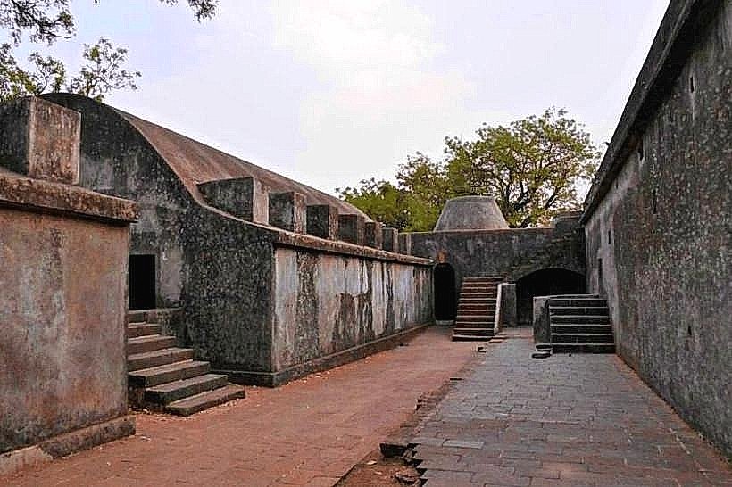
Visual Characteristics
The fort is constructed primarily fromlaterite stone. It is aquadrangular structure withbastions at each corner. The walls are approximately10 meters high. The architectural style reflectsearly colonial military design, emphasizing functionality over ornamentation.
Location & Access Logistics
Sewri Fort is situated approximately8 kilometers from the Mumbai city center. Access is viaSewri Fort Road, which connects toMahul Road. Public transport options includeBEST bus routes that stop near the Sewri railway station. From the station, it is a1.5 kilometer walk or a short auto-rickshaw ride.Limited parking is available near the fort entrance.
Historical & Ecological Origin
The fort was constructed in1680 by theBritish East India Company. Its original purpose was toguard the Mumbai harbor and serve as awatchtower against potential enemy incursions. The site itself is composed ofcoastal alluvial deposits common to the Mumbai region.
Key Highlights & Activities
Visitors canwalk along the ramparts for views of the harbor.Exploring the interior courtyards andexamining the remaining architectural features are primary activities. The fort is also a known location forbirdwatching, particularly during migratory seasons.
Infrastructure & Amenities
No permanent restrooms are located within the fort.Limited shade is available from the fort's structure itself.Cell phone signal (4G/5G) is generally available.No food vendors are present at the fort; visitors should bring their own provisions.
Best Time to Visit
Theearly morning (7:00 AM - 10:00 AM) andlate afternoon (4:00 PM - 6:00 PM) offer the most favorable lighting for photography and comfortable temperatures. Thewinter months (October to March) provide the most pleasant weather.No tide-specific access is required.
Facts & Legends
A local legend suggests that the fort was once used as aprison, though historical records do not extensively support this. A verified fact is that the fort's strategic position allowed it to monitorsea traffic entering and leaving the harbor during the colonial era.
Nearby Landmarks
- Sewri Flamingo Sanctuary: 0.8km South-West
- Mahul Fort: 2.1km East
- Wadala Truck Terminal: 3.5km North-West
- Sion Fort: 4.2km North