Landmark: Spearfish Canyon Scenic Byway
City: Spearfish
Country: USA South Dakota
Continent: North America
Spearfish Canyon Scenic Byway, Spearfish, USA South Dakota, North America
The Spearfish Canyon Scenic Byway is a 19-mile paved road traversing a limestone canyon in western South Dakota. It connects the city of Spearfish to the community of Cheyenne Crossing.
Visual Characteristics
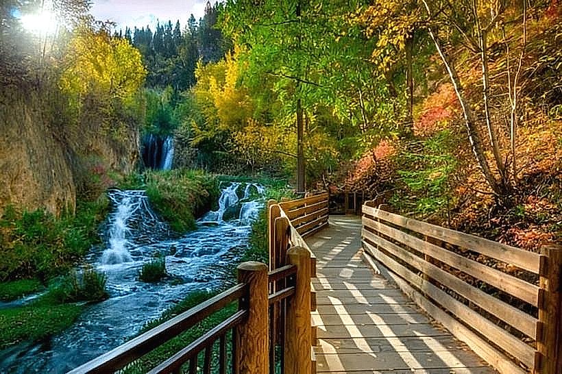
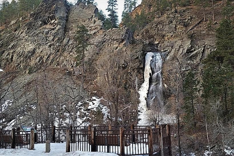
The canyon walls are composed of Paleozoic-era limestone, exhibiting vertical striations and varying shades of grey and white. The canyon floor is vegetated with a mix of deciduous trees, primarily aspen and birch, and coniferous species like pine and spruce. Spearfish Creek, a clear, cold-water stream, flows along the canyon floor, its color ranging from deep blue to emerald green depending on depth and light. Waterfalls, such as Roughlock Falls and Bridal Veil Falls, cascade over the limestone cliffs.
Location & Access Logistics
The byway begins at the intersection of US Highway 14A and Main Street in Spearfish, South Dakota. The western terminus is at Cheyenne Crossing, where US Highway 14A intersects with SD Highway 85. The drive from downtown Spearfish to the start of the byway is approximately 2 miles. Parking is available at designated pull-offs and trailheads along the route. No public transportation services operate directly on the byway.
Historical & Ecological Origin
The canyon was carved by glacial meltwater and the Spearfish Creek over millions of years. The area was historically used by Native American tribes, including the Lakota and Crow. The Spearfish Canyon Scenic Byway was designated in 1991. The surrounding Black Hills National Forest is a temperate coniferous forest ecosystem.
Key Highlights & Activities
Hiking is possible on numerous trails, including the 2.5-mile Devils Bathtub Trail and the 0.5-mile Roughlock Falls Trail. Photography opportunities are present at the waterfalls and along the creek. Fishing for trout is permitted in Spearfish Creek, with specific regulations applying. Scenic driving is the primary activity, with multiple overlooks providing canyon views.
Infrastructure & Amenities
Restrooms are available at the Roughlock Falls Day Use Area and the entrance to the Spearfish Canyon Lodge. Shade is provided by the tree canopy in many areas. Cell phone signal is intermittent to non-existent throughout most of the canyon. Limited food and drink options are available at the Spearfish Canyon Lodge and the Cheyenne Crossing general store.
Best Time to Visit
For optimal lighting for photography, early morning and late afternoon offer angled sunlight that highlights the canyon walls. The best months for visiting are from May through October, when the road is typically clear of snow and ice. Spring (April-May) offers flowing waterfalls due to snowmelt. Fall (September-October) provides autumn foliage colors.
Facts & Legends
The Devils Bathtub is a natural pool carved into the rock by Spearfish Creek. Its formation is a result of continuous water flow eroding the limestone over centuries. Local lore suggests the water possesses restorative properties, though this is unverified.
Nearby Landmarks
- Roughlock Falls (0.1km West)
- Bridal Veil Falls (4.5km Southwest)
- Spearfish Canyon Lodge (3.8km Southwest)
- Devils Bathtub Trailhead (6.2km Southwest)
- Cheyenne Crossing (19km West)