City: Kakamega
Country: Kenya
Continent: Africa
Kakamega, Kenya, Africa
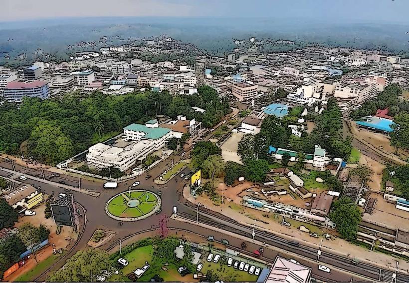
Kakamega is the administrative capital of Kakamega County and the primary gateway to the last remaining tropical rainforest in Kenya. It is situated at an elevation of 1,535 meters in the Lake Victoria basin, approximately 50 kilometers north of Kisumu.
Historical Timeline
Kakamega was established as a colonial administrative center in the early 20th century. Its name is derived from the Luhya word for "pinch," referring to the way the local people prepared maize meal (ugali). The primary event shaping its current urban form was the 1930s gold rush, which briefly turned the town into a mining hub. Following the decline of mining, the city transitioned into an agricultural and educational center, further catalyzed by the 2006 establishment of the Masinde Muliro University of Science and Technology.
Demographics & Population
The estimated metropolitan population for 2026 is 125,000. The demographics are predominantly Luhya (comprising various sub-groups like the Isukha and Idakho). The median age is approximately 19.1 years.
Urban Layout & Key Districts
The city is organized along the A1 highway (Kisumu-Kitale road).
The CBD: A compact commercial hub centered on the main market and government offices.
Milimani: An affluent residential district characterized by greenery and low-density housing.
Amalemba: A high-density residential area.
University District: The northern sector dominated by student housing and academic facilities.
Top City Landmarks
Kakamega Forest National Reserve: The only remaining Guineo-Congolian rainforest in Kenya, home to rare primates and endemic birds.
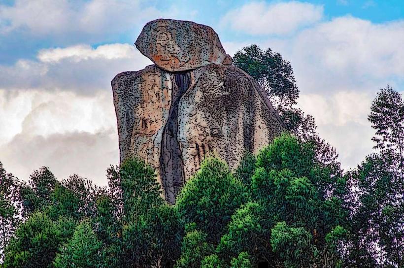
Crying Stone of Ilesi: A massive rock formation that appears to "weep" water from its center, located 5 km south of town.
Masinde Muliro University: A major academic landmark shaping the city's youth culture.
Bukhungu Stadium: A primary venue for regional football and cultural events.
Muliro Gardens: A central public park known for its bamboo walks and history.
Transportation Network
Intra-city transit is dominated by Boda Bodas and Tuk-tuks. Matatus provide frequent links to Kisumu and Bungoma. There is no active passenger rail service. The Kakamega Airstrip serves limited charter flights, with most commercial travelers using the Kisumu International Airport (50 km away). Traffic is generally low, though the A1 highway experiences heavy agricultural transit.
Safety & "Red Zones"
The general safety level is high. Petty theft occurs in the main market and bus park. There are no specific "red zones," but travelers should avoid entering the Kakamega Forest after dark without an authorized guide due to dense terrain and wildlife.
Digital & Financial Infrastructure
Internet speeds average 25–40 Mbps. Main carriers are Safaricom and Airtel. M-Pesa is the primary medium for financial transactions. ATMs are ubiquitous in the CBD along the main highway. Credit card acceptance is restricted to large supermarkets and major hotels.
Climate & Air Quality
Temperatures range from 18°C to 29°C. The climate is tropical and very humid, with heavy rainfall throughout the year, sustaining the surrounding rainforest. Air quality is exceptional. Significant weather risks include frequent afternoon thunderstorms and flash flooding in low-lying areas.
Culture & Social Norms
English and Swahili are used for business; Luhya is the dominant local language. The culture is famous for Isukuti (traditional drumming and dance) and bullfighting festivals in nearby Malinya. Tipping is standard at 5–10%. Shaking hands is the standard greeting.
Accommodation Zones
Forest Perimeter: Recommended for eco-lodges and nature retreats.
Milimani: Recommended for quiet, professional hotel stays.
Local Cost Index
1 Espresso: 220 KES ($1.45 USD)
1 Standard Lunch (Chicken/Ugali): 650 KES ($4.20 USD)
1 Short Boda Boda Trip: 100 KES ($0.65 USD)
Nearby Day Trips
Malinya: 15 km (Site of traditional Luhya bullfighting).
Mumias: 30 km (Historic sugar-producing town).
Webuye: 45 km (Site of the Broderick Falls).
Facts & Legends
Kakamega Forest is often called the "Canopy of Gold" due to its history of gold mining. A local legend surrounding the Crying Stone of Ilesi claims the stone "cries" when there is a significant social or political event affecting the Luhya community. A verified historical oddity is that the forest was once part of a continuous belt of rainforest that stretched all the way across Central Africa to the Atlantic Ocean.