
Landmark: Crying Stone of Ilesi
City: Kakamega
Country: Kenya
Continent: Africa
Crying Stone of Ilesi, Kakamega, Kenya, Africa
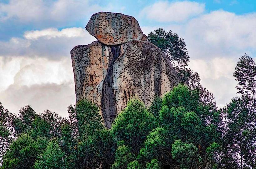
The Crying Stone of Ilesi is a geological formation located in Kakamega County, Kenya. It is a large rock outcrop characterized by a unique weeping appearance.
Visual Characteristics
The formation consists of a large, dark grey dolerite rock. Water seeps from numerous fissures and cracks across its surface, creating the visual effect of tears. The rock stands approximately 40 meters high and is covered in moss and lichen in damp areas.
Location & Access Logistics
The Crying Stone is situated approximately 10 kilometers west of Kakamega town. Access is via the Kakamega-Webuye road (B21). Turn south onto a dirt track approximately 5 kilometers from Kakamega town, marked by local signage. The track is approximately 2 kilometers long and can be rough, particularly after rain. Parking is available at the base of the formation. Public transport to Kakamega town is available via bus services from major Kenyan cities. Local matatus (minibuses) operate from Kakamega town towards the general direction of Ilesi, requiring a short walk from the nearest drop-off point.
Historical & Ecological Origin
The Crying Stone is a natural geological feature, a remnant of ancient volcanic activity in the region. It is composed of dolerite, a type of igneous rock. Its formation is attributed to weathering and erosion processes over millennia, which have carved the fissures from which water emerges.
Key Highlights & Activities
Observation of the water seepage phenomenon. Photography of the rock formation. Guided walks around the base of the stone are available, led by local guides who explain the geological and cultural significance. Climbing the rock is not permitted due to safety concerns and its cultural importance.
Infrastructure & Amenities
Basic amenities are present. There are small stalls operated by local vendors selling water and snacks near the parking area. Basic pit latrines are available. Shade is limited, primarily provided by nearby trees. Cell phone signal (4G) is generally available.
Best Time to Visit
The "weeping" effect is most pronounced during and immediately after the rainy seasons (March-May and October-November). The best time of day for photography is generally mid-morning or late afternoon when the sun angle provides better contrast and avoids harsh midday light. The site is accessible year-round, but the access track can be challenging during heavy rainfall.
Facts & Legends
Local folklore attributes the "tears" to a woman named Ilesi who was cursed to weep eternally for abandoning her child. Geologically, the water originates from underground springs that emerge through the porous rock structure.
Nearby Landmarks
- Kakamega Forest National Reserve (5km Northeast)
- Masinde Muliro University of Science and Technology (7km East)
- Kakamega County Stadium (8km East)
- Isukha Cultural Centre (3km Southwest)


