Landmark: Alofaaga Blowholes (Taga Blowholes)
City: Taga
Country: Samoa
Continent: Australia
Alofaaga Blowholes (Taga Blowholes), Taga, Samoa, Australia
The Alofaaga Blowholes, also known as the Taga Blowholes, are a series of natural marine geysers located on the rugged southern coastline of Savai'i, Samoa. They are considered among the most powerful blowholes in the world.
Visual Characteristics
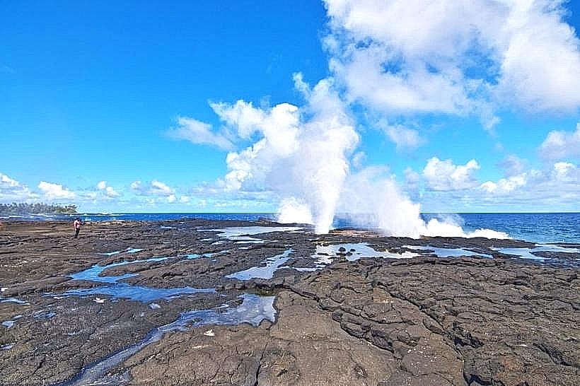
The site consists of a flat, expansive plateau of black basaltic rock honeycombed with vertical shafts. When large swells from the South Pacific strike the coast, seawater is forced through these underwater lava tubes and propelled upward through the holes. The resulting geysers can reach heights of over 30 meters (100 feet), accompanied by a deep, thunderous roar and a fine mist of salt spray. The surrounding terrain is stark, dominated by weathered volcanic rock and minimal vegetation.
Location & Access Logistics
The blowholes are situated approximately 25km southwest of Salelologa. Access is via the village of Taga; a signposted turn-off from the Main Island Road leads to a 2km unpaved track. A village entry fee is required at the roadside booth. While a 2WD vehicle can reach the parking area in dry conditions, a 4WD is preferable for the final stretch. From the parking area, it is a 100-meter walk over uneven lava rock to reach the primary blowhole vents.
Historical & Ecological Origin
The blowholes were formed by ancient lava tubes-hollow conduits created when the surface of a lava flow hardened while the molten interior continued to drain into the sea. Over centuries, the ceiling of these tubes collapsed at specific inland points, while the sea-end remained open. Ecologically, the area is a high-energy intertidal zone where the rock is inhabited by resilient mollusks and crustaceans adapted to extreme hydraulic pressure.
Key Highlights & Activities
Observation of the water eruptions is the primary activity. A common local demonstration involves throwing coconuts into the blowhole vents just before a swell hits, which launches the husks high into the air. The site is a premier location for high-speed photography. Visitors can also explore the adjacent coastal cliffs to see the force of the waves against the basalt shelf.
Infrastructure & Amenities
Infrastructure is limited to several traditional wooden fales for shade and resting near the viewing area. There are no public restrooms or running water directly at the blowholes; these facilities are located in Taga village. Cell phone signal is generally reliable (4G) due to the flat, coastal terrain. Sturdy, non-slip footwear is essential as the volcanic rock is sharp and becomes extremely slippery when wet.
Best Time to Visit
The blowholes are most dramatic during high tide and periods of strong southern swells, which produce the highest water columns. Mid-morning is optimal for photography to ensure the sun is positioned to illuminate the spray, occasionally creating rainbows in the mist. The site is open Monday through Saturday; access is typically restricted on Sundays.
Facts & Legends
A unique feature of this site is the sheer volume of water displaced; the pressure is sufficient to vibrate the ground underfoot. A practical safety tip: visitors must stay well back from the vents, as the timing of the eruptions is unpredictable and the force of the incoming air and water can be hazardous.
Nearby Landmarks
Taga Coastal Cliffs – 0.5km East
Taga Village – 1.4km North
Mu Pagoa Waterfall – 9.0km East
Lovers' Leap – 12.0km West