Landmark: Devil’s Kettle
City: Grand Marais
Country: USA Minnesota
Continent: North America
Devil’s Kettle, Grand Marais, USA Minnesota, North America
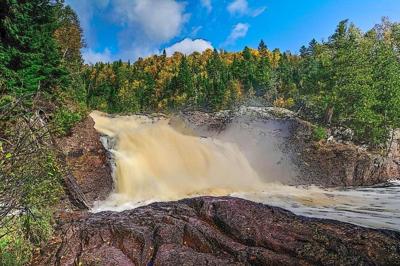
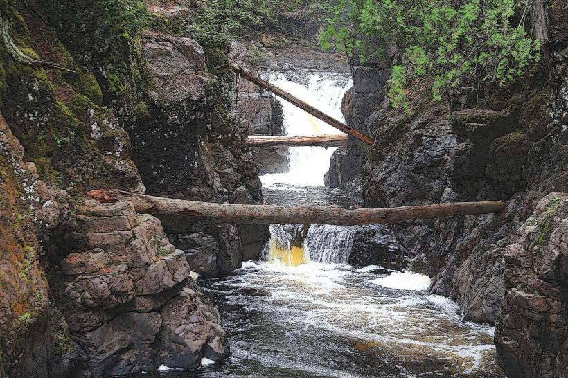
Devil's Kettle is a geological formation located on the North Shore of Lake Superior near Grand Marais, Minnesota. It is a waterfall that splits into two streams, with one flowing into the Brule River and the other disappearing into a cavern.
Visual Characteristics
The formation consists of a 30-foot waterfall cascading over a series of rock ledges. The water is typically clear to light brown, depending on recent rainfall. The surrounding area is characterized by dense coniferous forest, primarily pine and spruce, with exposed Precambrian bedrock. The cavern entrance is approximately 10 feet wide and 6 feet high.
Location & Access Logistics
Devil's Kettle is situated within Judge C.R. Magney State Park. Access is via Highway 61, approximately 10 miles northeast of Grand Marais. Turn north onto County Road 14 (Devil's Track Road) and follow signs for the park entrance. Parking is available at the main park lot. A 1-mile hiking trail, marked as the "Devil's Kettle Trail," leads from the parking area to the waterfall. The trail is a moderate difficulty, with some elevation change.
Historical & Ecological Origin
The geological formation is a result of differential erosion. The Brule River, a tributary of Lake Superior, flows over a layer of resistant volcanic rock. A weaker section of this rock has eroded to form the cavern, allowing a portion of the river to disappear underground. The surrounding bedrock dates back approximately 1.1 billion years.
Key Highlights & Activities
Observation of the waterfall and the split flow is the primary activity. Hiking the Devil's Kettle Trail provides views of the cascade and the surrounding forest. Photography is possible from designated viewpoints along the trail.
Infrastructure & Amenities
Restrooms are available at the Judge C.R. Magney State Park main parking lot. There are no food vendors at the trailhead or near the formation. Cell phone signal is intermittent along the trail and generally available at the park entrance.
Best Time to Visit
The best time for clear water visibility is during drier periods. Spring melt can increase water volume and turbidity. For photography, late afternoon light offers softer illumination on the falls. The trail is accessible year-round, but winter conditions may require snowshoes or skis and can obscure the cavern entrance.
Facts & Legends
Local folklore suggests that anything thrown into the subterranean portion of the waterfall will never be seen again, leading to speculation about its ultimate destination. Scientific investigation has confirmed the water eventually rejoins the Brule River downstream, though the exact path remains unmapped.
Nearby Landmarks
- Judge C.R. Magney State Park Visitor Center - 0.2km South
- Brule River - Adjacent
- Lake Superior - 1.5km Southeast
- Grand Marais Lighthouse - 10km Southwest
- Tettegouche State Park - 35km Southwest