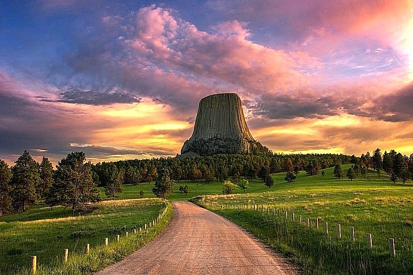
Landmark: Devils Tower National Monument
City: Sundance
Country: USA Wyoming
Continent: North America
Devils Tower National Monument, Sundance, USA Wyoming, North America
Devils Tower National Monument is a prominent geological formation located in northeastern Wyoming, USA.
Visual Characteristics
The monument is a large, columnar igneous intrusion composed of phonolite porphyry. It rises 1,267 feet (386 meters) above the Belle Fourche River valley floor. The tower's surface is characterized by vertical cracks and columns, giving it a textured appearance. Its color ranges from gray to reddish-brown depending on the light and weathering.
Location & Access Logistics
Devils Tower is situated 32 miles (51 km) east of Sundance, Wyoming, accessible via Wyoming Highway 110 (Devils Tower Highway). The drive from Sundance takes approximately 45 minutes. A paved road encircles the base of the tower, providing access to parking areas. There is no public transportation directly to the monument; visitors typically arrive by private vehicle. The nearest major airport is Gillette-Campbell County Airport (GCC), located about 60 miles (97 km) away.
Historical & Ecological Origin
Devils Tower is an eroded remnant of a laccolith, a type of igneous intrusion that pushed up surrounding rock layers without erupting. It formed approximately 40 to 50 million years ago. The tower was designated a National Monument on September 24, 1906, making it the first in the United States. Indigenous peoples, including the Lakota, Cheyenne, and Crow, have long considered the site sacred.
Key Highlights & Activities
Activities include hiking the 1.3-mile (2.1 km) paved Tower Trail that circles the base of the formation. Several other hiking trails, such as the Red Beds Trail and the South Side Trail, offer different perspectives. Rock climbing is permitted on the tower, though specific routes and regulations apply. Ranger-led programs are offered seasonally. Wildlife viewing, including prairie dogs and various bird species, is common.
Infrastructure & Amenities
The monument features a visitor center with exhibits and restrooms. Picnic areas with tables and shade structures are available. Drinking water is accessible at the visitor center and near the Tower Trail trailhead. Cell phone service is intermittent within the monument boundaries, with limited 4G/5G coverage. Food vendors are not present within the monument; visitors should bring their own provisions or plan to eat in nearby towns like Sundance or Hulett.
Best Time to Visit
The best time for photography is during sunrise and sunset, when the low-angle light accentuates the tower's features. The months of May through September offer the most favorable weather conditions for outdoor activities, with daytime temperatures typically ranging from 60°F to 80°F (15°C to 27°C). Spring (April-May) can bring cooler temperatures and potential for snow, while autumn (October) offers fewer crowds but cooler weather. There are no tide-dependent activities at this inland location.
Facts & Legends
A local legend states that the columns on the tower's surface are the marks left by a giant bear scratching its claws as it tried to reach seven sisters who had climbed the tower to escape it. Geologists explain these as natural jointing patterns in the igneous rock. Visitors are advised to stay on marked trails and respect the cultural significance of the site.
Nearby Landmarks
- Belle Fourche River (Adjacent)
- Bear Lodge Mountains (Adjacent)
- Hulett, Wyoming (15km Northwest)
- Sundance, Wyoming (32km Southwest)
- Keyhole State Park (40km Southeast)