Landmark: Minneopa Falls
City: Mankato
Country: USA Minnesota
Continent: North America
Minneopa Falls, Mankato, USA Minnesota, North America
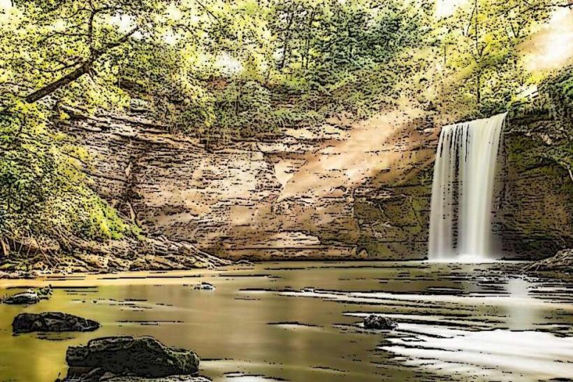
Minneopa Falls is a two-tiered waterfall located within Minneopa State Park, near Mankato, Minnesota.
Visual Characteristics
The falls consist of two distinct drops. The upper falls cascade approximately 30 feet over a limestone escarpment. The lower falls descend another 20 feet, forming a pool at its base. The surrounding gorge is characterized by exposed limestone rock formations and dense deciduous forest, primarily oak and maple.
Location & Access Logistics
Minneopa Falls is situated within Minneopa State Park, approximately 8 miles southwest of Mankato, Minnesota. Access is via County Road 17 (also known as Minneopa Road). The park entrance fee is required. Parking is available at designated lots near the falls trailhead. Public transportation to the park is not available.
Historical & Ecological Origin
The falls are a result of the erosive power of Minneopa Creek acting upon the Paleozoic limestone bedrock of the region. The gorge was carved over thousands of years. Minneopa State Park was established in 1904, preserving the natural features of the area.
Key Highlights & Activities
Hiking trails provide access to both the upper and lower falls. The main trail to the lower falls is paved and approximately 0.25 miles from the parking area. A more strenuous trail leads to the top of the upper falls. Observation platforms are present at both levels. During winter, the falls can freeze, creating ice formations.
Infrastructure & Amenities
Restrooms are available at the main park entrance and near the falls parking area. Picnic tables and shelters are located within the park. Cell phone signal (4G/5G) is intermittent within the park boundaries. No food vendors are present within the park; visitors should bring their own provisions.
Best Time to Visit
For optimal lighting for photography, early morning or late afternoon provides angled sunlight on the falls. The best months for visiting are typically May through October, when trails are clear of snow and ice. Spring (April-May) offers higher water flow due to snowmelt. Winter visits are possible for viewing ice formations, but require appropriate cold-weather gear and caution on icy trails.
Facts & Legends
The name "Minneopa" is derived from the Dakota language, meaning "water" or "double water," referring to the two tiers of the falls. Local lore suggests the falls were a significant gathering place for Indigenous peoples long before European settlement.
Nearby Landmarks
- Minneopa State Park (0km, encompassing)
- Blue Earth River (3km Southwest)
- Fort Leavenworth Historical Site (10km Southwest)
- Downtown Mankato (13km Northeast)
- Sibley Park (14km Northeast)