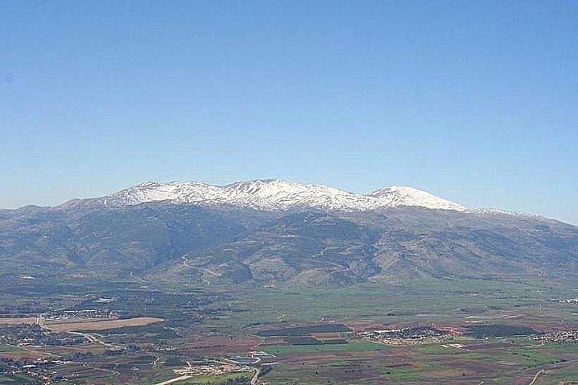
Landmark: Mount Hermon (Jabal el-Sheikh)
City: Hasbaya
Country: Lebanon
Continent: Asia
Mount Hermon (Jabal el-Sheikh), Hasbaya, Lebanon, Asia
Mount Hermon, professionally known as Jabal el-Sheikh, is a mountain cluster constituting the southern terminal segment of the Anti-Lebanon mountain range. The summit straddles the border between Lebanon and Syria, commanding the highest elevation zone in the immediate Levant region.
Visual Characteristics
Mount Hermon (Jabal el-Sheikh) rises to a maximum elevation of 2,814 meters above sea level. The mountain is primarily composed of heavily karstified Jurassic limestone, resulting in jagged rock formations, sinkholes, and steep, eroded scree slopes. The upper peaks feature a broad, elongated ridgeline that remains covered in dense snow cover for up to six months of the year, contrasting sharply with the arid, light-grey and beige tones of the exposed rock faces during summer. Vegetation is sparse above the tree line, consisting chiefly of low-growing alpine shrubs, xeric grasses, and mountain oaks on the lower elevations.
Location & Access Logistics
The western slopes of Mount Hermon (Jabal el-Sheikh) are located roughly 90 kilometers southeast of Beirut and 25 kilometers from the regional hub of Marjayoun. Access from the Beqaa Valley is achieved via the main road to the mountain town of Rashaya al-Wadi, where secondary mountain tracks proceed toward the higher elevations. There are no structured public transit systems or designated parking lots at the upper levels; private 4WD vehicles must navigate unpaved, winding utility routes. Access near military border zones is restricted and requires prior permit approval from regional defense authorities.
Historical & Ecological Origin
Geologically, Mount Hermon (Jabal el-Sheikh) is an anticlinal fold structure that emerged during the alpine orogeny. Ecologically, it is classified as a high-altitude Mediterranean alpine ecosystem, serving as the primary freshwater catchment area for the Jordan River system and regional aquifers via snowmelt infiltration into its vast karst network. Historically, the mountain was revered as a sacred site by ancient civilizations, containing numerous Canaanite, Roman, and Byzantine temple foundations erected on its lower slopes and sub-peaks.
Key Highlights & Activities
Hiking the high-altitude trails starting from the outskirts of Rashaya al-Wadi during the summer season.
Surveying the geological karst depressions and cave networks situated across the western ridge.
Birdwatching during the biannual migratory seasons when large raptors navigate the mountain thermal currents.
Photographing the snowline transitions and panoramic expanses of the Beqaa Valley from exposed high-altitude outcrops.
Infrastructure & Amenities
Infrastructure on Mount Hermon (Jabal el-Sheikh) is extremely limited and primarily non-existent outside of bordering military installations. There are no public restrooms, formal picnic zones, potable water sources, or shaded visitor shelters on the mountain. Cellular signal is unstable, fluctuating between 3G, 4G, and total disconnection depending on terrain blockage and proximity to border telecommunication towers. No food, fuel, or commercial vendors operate on the mountain proper; all supplies must be procured beforehand in adjacent towns.
Best Time to Visit
The ideal months for terrestrial exploration and trekking are from late June to October, when the high-altitude passes are clear of snowpack. The most favorable window for photography is between 05:30 and 07:30, capitalizing on clear morning visibility before convective valley mist ascends and obscures the summit topography.
Facts & Legends
The historic name Jabal el-Sheikh translates literally to "Mountain of the Chief" or "Snowy Mountain," a reference to its snow-capped peak resembling a white beard or turban worn by regional elders. In ancient texts, the mountain is noted as a territorial landmark and a site of religious assemblies, with archeological teams locating the ruins of the highest Roman temple in the world, known as Qasr Antar, on a sub-peak just under the main summit.
Nearby Landmarks
Rashaya Citadel: 2.3km Northwest
Rashaya Old Souk: 2.5km Northwest
Al-Chhabib Historic House: 2.6km Northwest
Our Lady of Deliverance Church: 2.7km Northwest