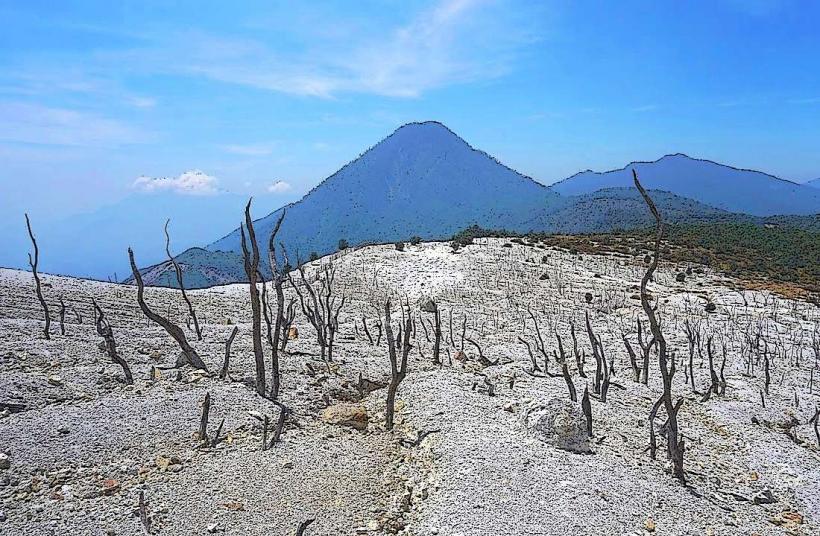
Landmark: Mount Papandayan
City: Bandung
Country: Indonesia
Continent: Asia
Mount Papandayan, Bandung, Indonesia, Asia
Mount Papandayan is an active stratovolcano located in West Java, Indonesia, approximately 70 kilometers south of Bandung.
Visual Characteristics
The volcano exhibits a complex crater system with active fumaroles and hot springs. The slopes are characterized by dense tropical rainforest vegetation, with areas of exposed volcanic rock and ash. The summit elevation reaches 2,665 meters (8,743 feet). The prevailing colors are greens from the foliage, grays and browns from volcanic deposits, and white from sulfurous deposits around fumaroles.
Location & Access Logistics
Access to Mount Papandayan is typically via the town of Garut. From Bandung, take the national route 3 (Jalan Raya Bandung-Garut) south for approximately 70 kilometers to Garut. From Garut, follow Jalan Papandayan for approximately 15 kilometers to the base camp area. Parking is available at the base camp, which serves as the primary entry point. Public transport options involve taking a bus from Bandung to Garut, then a local angkot (minibus) or ojek (motorcycle taxi) to the mountain entrance.
Historical & Ecological Origin
Mount Papandayan is a stratovolcano formed by volcanic activity over millennia. Its current form is a result of multiple eruptions, with significant collapses and resurgences. The most notable eruption occurred in 1772, causing widespread destruction. Ecologically, it is part of the Sunda Arc, a geologically active zone.
Key Highlights & Activities
Hiking to the summit crater is a primary activity. Visitors can observe active fumaroles, sulfur deposits, and hot springs within the crater complex. Trekking routes include the main trail to the Kawah Papandayan (Papandayan Crater) and the more challenging path to the summit. Photography of the volcanic landscape and surrounding flora is common. Camping is permitted in designated areas.
Infrastructure & Amenities
Basic facilities are available at the base camp, including restrooms and small food stalls selling local snacks and drinks. Shade is provided by the forest canopy on the lower trails. Cell phone signal is intermittent, with 4G coverage generally limited to the base camp area. There are no formal restaurants on the mountain itself.
Best Time to Visit
The dry season, from April to September, offers the most favorable weather conditions for hiking. Mornings generally provide clearer views and cooler temperatures. The best time of day for photography is typically early morning or late afternoon when the light is softer. There are no tide-specific considerations for this inland volcano.
Facts & Legends
A local legend suggests that the mountain is inhabited by spirits and that offerings should be made to ensure safe passage. Historically, the 1772 eruption was so powerful that it destroyed 40 villages and caused significant ashfall as far away as the coast.
Nearby Landmarks
- Taman Wisata Alam Kawah Putih (White Crater Nature Park) - 25km Southwest
- Situ Bagendit (Bagendit Lake) - 10km Northwest
- Taman Safari Indonesia II (Indonesian Safari Park II) - 40km North
- Tangkuban Perahu (Volcano) - 75km North