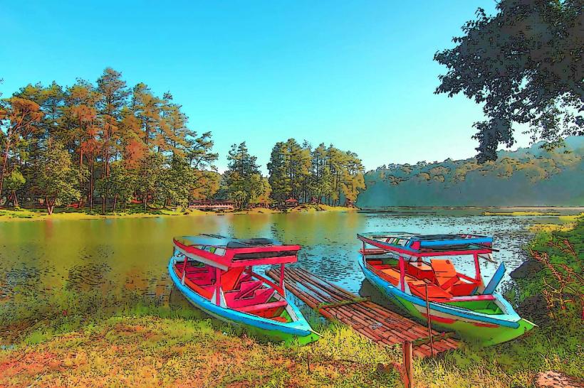
Landmark: Situ Patenggang
City: Bandung
Country: Indonesia
Continent: Asia
Situ Patenggang, Bandung, Indonesia, Asia
Situ Patenggang is a lake located in the Pengalengan district of Bandung Regency, West Java, Indonesia. It is a natural reservoir surrounded by tea plantations.
Visual Characteristics
The lake's surface is approximately 45 hectares in area. Water color varies from deep blue to green depending on light conditions and depth. The surrounding landscape is characterized by rolling hills covered in dense tea plantations, with scattered pine trees. The terrain is undulating.
Location & Access Logistics
Situ Patenggang is situated approximately 45 kilometers south of Bandung city center. Access is via Jalan Raya Ciwidey-Patenggang. From Bandung, take Jalan Gatot Subroto, then Jalan Kiaracondong, followed by Jalan Ciwidey. The final stretch is Jalan Raya Ciwidey-Patenggang. Parking is available at designated areas near the lake entrance, with a fee. Public transport options are limited; shared minibuses (angkot) from Bandung to Ciwidey are available, requiring a transfer to another angkot or a motorcycle taxi (ojek) for the final leg to Situ Patenggang.
Historical & Ecological Origin
Situ Patenggang is a natural lake formed by geological processes. Its formation is linked to the volcanic activity and subsequent erosion in the region, creating a basin that collects rainwater and runoff from the surrounding highlands. The area is part of the Malabar volcanic complex.
Key Highlights & Activities
Boating activities are available on the lake, including pedal boats and rowboats. Visitors can walk along the lake shore. Hiking trails are present within the surrounding tea plantations. The "Batu Cinta" (Love Stone) is a prominent rock formation on a small island accessible by a bridge, often visited by couples.
Infrastructure & Amenities
Restrooms are available at the entrance and at some food stalls. Shade is provided by trees and some covered seating areas. Cell phone signal (4G) is generally available in most areas. Food vendors selling local snacks and beverages are located near the parking areas and along the lake shore.
Best Time to Visit
The best time of day for photography is generally in the morning (07:00-09:00) or late afternoon (15:00-17:00) when the sun angle provides softer light and highlights the contours of the landscape. The dry season, from June to September, offers clearer skies and less rainfall. There are no specific tide requirements as it is a freshwater lake.
Facts & Legends
A local legend associated with Batu Cinta states that if two people stand on opposite sides of the stone and make a wish, their wish will be granted. Another story tells of a heartbroken princess who cried so much that her tears formed the lake.
Nearby Landmarks
- Kawah Putih (White Crater): 5km Southwest
- Glamping Lakeside Rancabali: 1km Northwest
- Taman Wisata Alam Patahan: 3km South
- Kebun Teh Rancabali: Adjacent