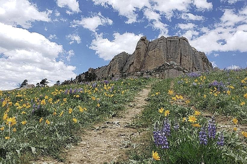
Landmark: Steamboat Point Trail
City: Sheridan
Country: USA Wyoming
Continent: North America
Steamboat Point Trail, Sheridan, USA Wyoming, North America
Steamboat Point Trail is a geological formation located in Sheridan, Wyoming, USA.
This site features prominent sandstone outcrops and a network of trails.
Visual Characteristics
The primary visual element is the exposed sandstone, exhibiting layers of varying colors from light tan to reddish-brown. The rock formations are characterized by erosion patterns, creating distinct shapes. Vegetation is sparse, consisting mainly of native grasses and low-lying shrubs adapted to arid conditions. The trail itself is unpaved, with a compacted dirt and gravel surface.
Location & Access Logistics
Steamboat Point Trail is situated approximately 8 kilometers (5 miles) east of downtown Sheridan. Access is via East Brundage Road, which transitions into a gravel road leading to the trailhead. Parking is available at a designated gravel lot at the trailhead. No public transport services operate directly to this location.
Historical & Ecological Origin
The sandstone formations at Steamboat Point are part of the Lance Formation, dating back to the Late Cretaceous period. These sedimentary rocks were deposited in a shallow marine and deltaic environment. The erosion that shaped the current landscape occurred over millions of years.
Key Highlights & Activities
Hiking is the primary activity. The main trail extends approximately 2.5 kilometers (1.5 miles) to a prominent overlook. Observation of geological strata is possible along the trail. Photography of the rock formations is a common pursuit.
Infrastructure & Amenities
The trailhead has a small, unpaved parking area. No restrooms, shade structures, or food vendors are present at the site. Cell phone signal (4G/5G) is intermittent and generally unreliable.
Best Time to Visit
For photography, early morning or late afternoon provides optimal lighting conditions for the sandstone colors. The months of May through October offer the most favorable weather, with daytime temperatures generally ranging from 15°C to 25°C (59°F to 77°F). Avoid visiting during periods of heavy rain, as the unpaved trails can become muddy and slippery.
Facts & Legends
Local lore suggests the rock formations resemble a steamboat, hence the name. Geologically, the distinct layering is a result of sediment deposition over millions of years, preserving fossilized plant material and dinosaur footprints in some areas of the broader Lance Formation.
Nearby Landmarks
- Kendrick Park (2.5km West)
- Fetterman Battlefield State Historic Site (7km Southwest)
- Don Brown Nature Area (4km West)
- Sheridan County Museum (8km West)