
Landmark: The Wave
City: Kanab
Country: USA Utah
Continent: North America
The Wave, Kanab, USA Utah, North America
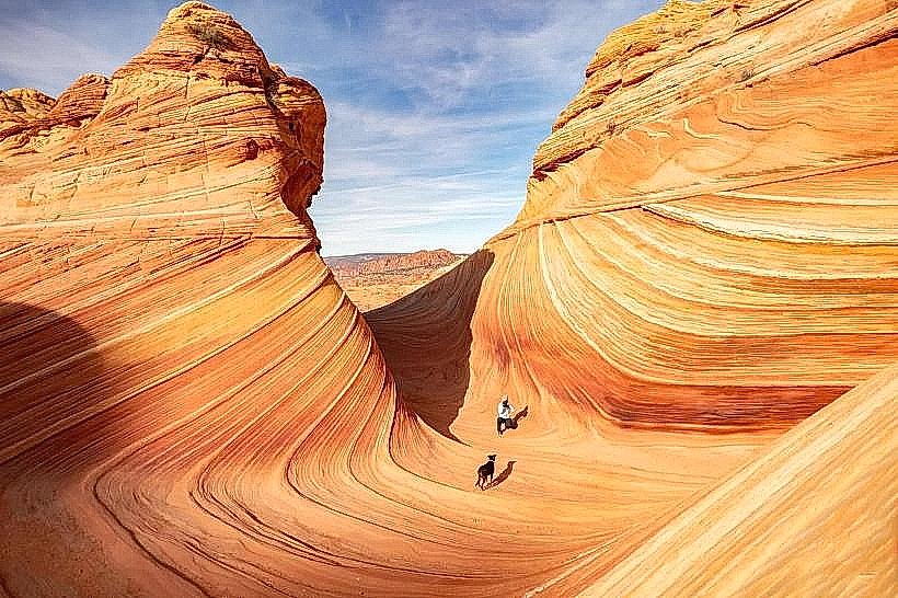
The Wave is a sandstone formation located in the Coyote Buttes section of the Paria Canyon-Vermilion Cliffs Wilderness Area, near Kanab, Utah.
This geological feature is characterized by its undulating, multi-colored sandstone walls, sculpted by wind and water erosion over millions of years.
Visual Characteristics
The Wave consists of Navajo Sandstone, displaying bands of red, orange, yellow, and white. The rock formations exhibit smooth, curved surfaces and overhangs, creating a visually dynamic landscape. The area is open to the sky, with no significant tree cover within the immediate formation.
Location & Access Logistics
The Wave is situated approximately 30 miles west of Kanab, Utah. Access is via House Rock Valley Road, a graded dirt road that can be rough and is not recommended for low-clearance vehicles, especially after rain. The trailhead is located at the Wire Pass Trailhead. Parking is extremely limited at the trailhead and is allocated via a lottery system. Public transport is not available to the trailhead. The nearest major airport is Las Vegas McCarran International Airport (LAS), approximately 200 miles away.
Historical & Ecological Origin
The Navajo Sandstone formation dates back to the Jurassic period, approximately 190 million years ago, when the area was a vast desert with large sand dunes. Over millennia, these dunes were buried, lithified into sandstone, and subsequently exposed and eroded by wind and water into their current shapes. The area is part of a desert ecosystem.
Key Highlights & Activities
Exploration of the sandstone formations is the primary activity. Visitors can walk through and around the sculpted rock. Photography is a common pursuit due to the unique light and shadow patterns. Hiking is permitted within the designated area.
Infrastructure & Amenities
There are no facilities within The Wave itself. Restrooms are available at the Wire Pass Trailhead parking area. Shade is minimal, provided only by rock overhangs. Cell phone signal is generally unreliable in the area.
Best Time to Visit
The best time of day for photography is typically mid-morning to early afternoon when sunlight illuminates the rock faces. The best months for visiting are spring (April-May) and fall (September-October) to avoid extreme summer heat and potential winter snow. Access is dependent on weather conditions, particularly after rainfall.
Facts & Legends
Access to The Wave is strictly controlled by a permit system, with only 20 permits issued daily for walk-in visitors and 10 permits issued daily via an online lottery. This is to protect the fragile environment and manage visitor numbers. The rock formations are known for their vibrant colors which change significantly with the angle of the sun.
Nearby Landmarks
- Wire Pass Trailhead (0.1km South)
- Coyote Buttes South (2km East)
- Alstrom Point (15km Northwest)
- White Pocket (25km Southwest)
- Grand Staircase-Escalante National Monument (Adjacent)


