Landmark: Wire Pass Trailhead
City: Kanab
Country: USA Utah
Continent: North America
Wire Pass Trailhead, Kanab, USA Utah, North America
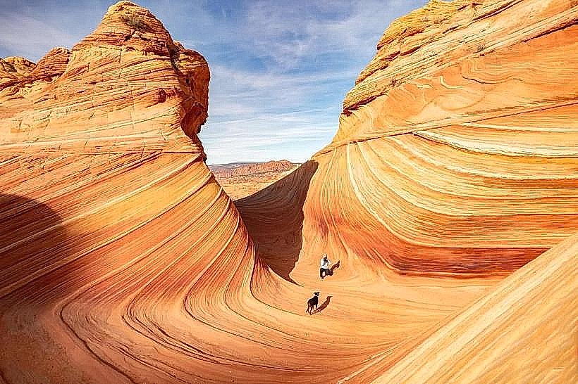
Wire Pass Trailhead provides access to a slot canyon in southern Utah, located west of Kanab.
Visual Characteristics
The trailhead itself is an undeveloped dirt area. The canyon walls are composed of Navajo Sandstone, exhibiting smooth, undulating surfaces sculpted by water erosion. The rock color ranges from pale orange to deep red, with variations due to mineral content. The canyon floor is primarily sand and gravel.
Location & Access Logistics
The trailhead is situated approximately 50 miles west of Kanab, Utah. Access is via House Rock Valley Road (BLM Road 101), a graded dirt road. From Highway 89, turn west onto House Rock Valley Road. The turnoff for Wire Pass Trailhead is approximately 30 miles down House Rock Valley Road. A high-clearance vehicle is recommended, especially after rain. Parking is limited to an informal dirt lot at the end of the road. No public transport services this location.
Historical & Ecological Origin
The slot canyon was formed by flash floods over millions of years, carving through the Navajo Sandstone. This process is a geological example of aeolian deposition and subsequent fluvial erosion. The area is part of the Colorado Plateau.
Key Highlights & Activities
Hiking the Wire Pass slot canyon is the primary activity. The trail descends into the canyon within 0.2 miles of the trailhead. The canyon narrows significantly in places, requiring navigation through tight passages. The trail continues for approximately 3.5 miles to connect with Buckskin Gulch.
Infrastructure & Amenities
There are no facilities at the trailhead. No restrooms, no shade structures, and no food vendors are present. Cell phone signal is unreliable to non-existent.
Best Time to Visit
The best time for hiking is during the cooler months of spring (April-May) and fall (September-October). Avoid visiting during monsoon season (July-September) due to the risk of flash floods. Early morning or late afternoon provides optimal lighting for photography within the canyon.
Facts & Legends
A permit is required for overnight stays and is available through the Bureau of Land Management (BLM). Day use does not require a permit, but visitors should check current conditions and flash flood potential before entering.
Nearby Landmarks
- Buckskin Gulch (0.1km North)
- Alstrom Point (15km Northwest)
- White Pocket (20km Southwest)
- Vermilion Cliffs National Monument (Adjacent)