Landmark: Little Cottonwood Canyon
City: Salt Lake City
Country: USA Utah
Continent: North America
Little Cottonwood Canyon, Salt Lake City, USA Utah, North America
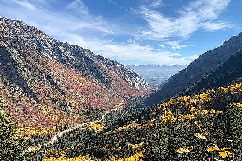
Little Cottonwood Canyon is a geological feature located southeast of Salt Lake City, Utah. It is a prominent canyon carved by glacial and fluvial processes.
Visual Characteristics
The canyon walls are composed primarily of Precambrian metamorphic rock, exhibiting a rough, fractured surface. Granite and quartzite are prevalent. Vegetation density varies with elevation, featuring coniferous forests (Douglas fir, subalpine fir) at higher altitudes and scrub oak and sagebrush in lower, drier areas. The canyon floor is largely occupied by the Cottonwood Creek, a fast-flowing stream with clear, cold water, particularly during spring snowmelt. Rock formations include steep cliffs, talus slopes, and evidence of past glacial activity such as U-shaped valleys and cirques.
Location & Access Logistics
Little Cottonwood Canyon is accessed via Utah State Route 210 (Little Cottonwood Canyon Road) from the city of Sandy, Utah, which is approximately 15 miles south of downtown Salt Lake City. The canyon entrance is about 10 miles from Sandy's city center. Parking is available at designated pull-offs and trailheads along SR-210. During winter months, avalanche control measures may lead to temporary road closures. Public transportation is provided by UTA (Utah Transit Authority) bus route 94, which operates seasonally and connects to the TRAX light rail system in Sandy.
Historical & Ecological Origin
The canyon's formation is primarily attributed to Pleistocene glaciation, with glaciers carving out the steep-sided, U-shaped valley. Subsequent erosion by Cottonwood Creek has further shaped the canyon floor. Historically, the canyon was used by indigenous peoples and later by settlers for mining and recreation. The area is part of the Wasatch-Cache National Forest.
Key Highlights & Activities
Hiking is a primary activity, with trails such as the Lake Blanche Trail (leading to three alpine lakes) and the Cecret Lake Trail (accessing Albion Basin, known for wildflowers in summer). Rock climbing opportunities exist on various granite formations. Skiing and snowboarding are major activities during winter at Snowbird and Alta ski resorts, located within the canyon. Photography is possible throughout the canyon, with specific viewpoints offering expansive vistas.
Infrastructure & Amenities
Restrooms are available at designated picnic areas and trailheads, as well as at the ski resorts. Shade is provided by the dense forest canopy at higher elevations. Cell phone signal (4G/5G) is intermittent and generally unreliable within much of the canyon. Food vendors and restaurants are primarily located at Snowbird and Alta ski resorts.
Best Time to Visit
For hiking and wildflower viewing, the months of July and August are optimal. For photography, early morning or late afternoon light provides favorable conditions for illuminating the canyon walls. Winter months (November to April) are dedicated to snow sports. Access to certain trails may be restricted by snowpack until late spring.
Facts & Legends
A notable geological feature is the "White Pine" area, known for its distinctive white granite formations. Local folklore sometimes refers to the canyon's challenging terrain and unpredictable weather as being influenced by mountain spirits.
Nearby Landmarks
- 0.5km West: Alta Ski Area
- 1.0km West: Snowbird Ski Resort
- 3.0km North: Twin Peaks Wilderness Area
- 4.0km South: Cardiff Fork Trailhead
- 4.5km East: Brighton Ski Resort (accessed via Guardsman Pass Road, seasonal)