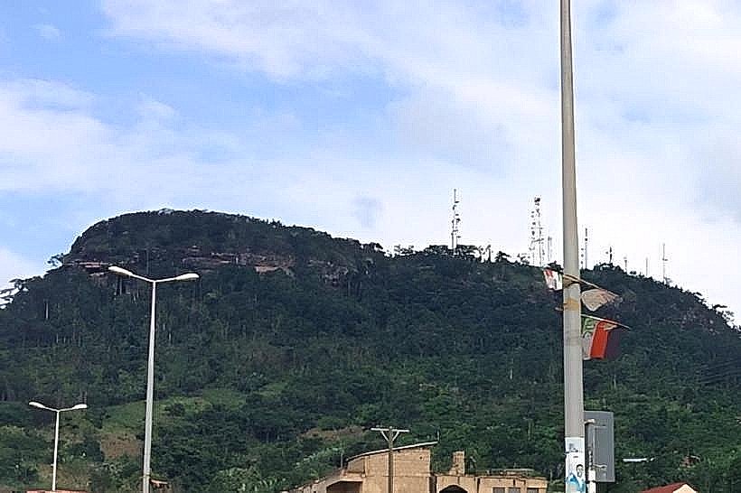
Landmark: Obuo Tabiri Mountain
City: Koforidua
Country: Ghana
Continent: Africa
Obuo Tabiri Mountain, Koforidua, Ghana, Africa
Obuo Tabiri Mountain is a prominent volcanic rock inselberg situated on the southern outskirts of Koforidua in the Eastern Region. It serves as a major topographical landmark and a site of spiritual significance for the New Juaben traditional area.
Visual Characteristics
The mountain is a massive, rounded granite and gneiss outcrop characterized by steep, grey rock faces and patches of dense tropical shrubbery. It rises approximately 500 meters above sea level, featuring a distinct "table-top" summit profile. The lower slopes are covered in thick secondary forest, while the upper elevations expose sheer stone surfaces with deep weather-induced fissures.
Location & Access Logistics
The site is located 3km south of the Koforidua city center. Access is via the Koforidua-Akropong road, with a turn-off toward the base of the mountain near the Koforidua Technical University. Hikers utilize a steep, winding dirt and stone path that starts near the mountain's base; the ascent typically takes 45 to 60 minutes. There is no formal parking lot, though vehicles can be left in cleared areas at the trailhead.
Historical & Ecological Origin
Geologically, Obuo Tabiri is a remnant of ancient volcanic activity within the Akwapim-Togo mountain range, formed through the uplift and subsequent erosion of surrounding softer rock. Historically, it is regarded as a sacred site by the local people, believed to be the home of a powerful deity (Tabiri) that protects the city of Koforidua.
Key Highlights & Activities
Hiking to the summit is the primary activity, offering a 360-degree panoramic view of the New Juaben municipality and the distant Volta Lake on clear days. Religious pilgrimages and prayer retreats are frequently held on the mountain slopes. Rock scrambling is possible on the upper sections, though no formal climbing infrastructure exists.
Infrastructure & Amenities
The mountain lacks modern infrastructure; there are no restrooms, paved paths, or visitor centers. Shade is provided by the forest canopy on the lower half of the climb, but the summit is entirely exposed. Cell phone signal (5G/4G) is exceptionally strong at the peak due to its elevation and proximity to city telecommunication masts.
Best Time to Visit
The optimal time for hiking is between 06:00 and 08:30 to avoid high humidity and direct solar radiation. The dry season (November to February) provides the best visibility and stable footing on the trail. Sunset photography from the peak is a common activity, provided hikers descend before total darkness.
Facts & Legends
According to local belief, the mountain is a "god" that accepted the New Juaben people when they migrated from Ashanti in the 19th century. A specific tip for visitors is that the mountain is often used for intensive fitness training by local athletes, and the summit houses several telecommunication towers which are restricted areas.
Nearby Landmarks
Koforidua Technical University: 0.8km North
Koforidua Beads Market: 3.2km North
Jackson Park: 3.4km North
Koforidua Central Mosque: 3.8km North
New Juaben Traditional Council Palace: 4.1km Northeast