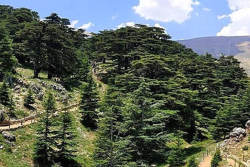
Landmark: Ain Zhalta Cedars
City: Aley
Country: Lebanon
Continent: Asia
Ain Zhalta Cedars, Aley, Lebanon, Asia
The Ain Zhalta Cedars, structurally integrated into the Ain Zhalta-Bmohray sector, constitute a protected forest zone located on the northern slopes of the Barouk mountain range within the Chouf District of the Mount Lebanon Governorate, Lebanon. This woodland represents one of the primary northern access points and distinct forest communities within the Al Shouf Cedar Nature Reserve.
Visual Characteristics
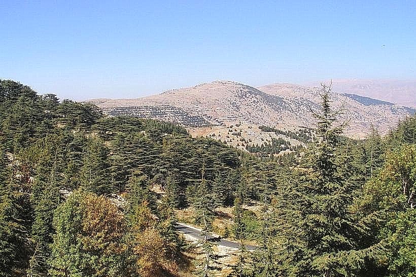
The Ain Zhalta Cedars are defined by mature and regenerating stands of Cedrus libani growing at altitudes between 1,200 and 1,980 meters above sea level. The woodland features a mix of broad, tabular older trees and younger conical specimens piercing a ground layer of fractured Jurassic limestone and highly structured red-brown Mediterranean soil. The terrain is markedly steep and rugged, displaying exposed karst formations, solution depressions, and gravelly scree slopes. The forest canopy is less dense than the neighboring Barouk sector, interspersed with wild oak, juniper, and stone pine trees that transition into barren sub-alpine crags near the ridgeline.
Location & Access Logistics
The Ain Zhalta Cedars are located 40 kilometers east of Beirut and approximately 17 kilometers southeast of Aley. Access from Beirut is achieved via the main Beirut-Damascus Highway, exiting south at Mdeirej toward Ammiq and passing through the villages of Nabeh el-Safa and Ain Zhalta. An unpaved but graded mountain road connects the village core to the designated park entrance gatehouse. Limited gravel parking is situated adjacent to the administrative entry checkpoint. There are no direct public transit routes to the forest entrance; visitors utilize regional minibuses to the village of Ain Zhalta or hire private 4WD vehicles to reach the trailhead.
Historical & Ecological Origin
Geologically, the site sits on porous, cavernous limestone strata shaped by tectonic uplift during the Pliocene epoch, which allows rapid infiltration of winter precipitation into the regional groundwater network supplying the Damour and Safa rivers. Historically, the area served as a timber harvesting zone for ancient regional empires, including the Assyrians under Sennacherib and Phoenician builders supplying naval projects. The forest was placed under formal state protection in 1996 through Law No. 532, which established the broader reserve boundaries to halt uncontrolled logging and grazing, enabling systemic ecological monitoring and reforestation programs.
Key Highlights & Activities
Hiking Section 18 of the Lebanon Mountain Trail, which traverses the rugged high-altitude limestone paths.
Utilizing the dedicated wildlife observation bunker to monitor native bird and mammal species.
Inspecting the ongoing artificial reforestation plots and seed beds managed by conservation rangers.
Landscape photography from the upper mountain spine, which offers panoramic views extending eastward into the Beqaa Valley.
Infrastructure & Amenities
The Ain Zhalta Cedars gatehouse provides basic visitor infrastructure, including a reception desk, printed trail maps, and primary emergency first-aid supplies. Graded dirt paths feature stone borders and basic wooden directional arrows at critical junctions. Public flush toilets are situated exclusively at the entry station. Cellular connectivity remains stable at 3G and 4G levels along the western village-facing slopes, but experiences complete signal dropouts within deep interior depressions and behind rock towers. No commercial food stalls or restaurants operate inside the forest limits, but multiple establishments are accessible in Ain Zhalta village 3 kilometers down the ridge.
Best Time to Visit
The optimal period for hiking and field observation is from May to October when the mountain trails are entirely clear of snowpack. The most favorable window for architectural and landscape photography occurs between 06:30 and 08:30, exploiting the clear morning atmosphere before convective valley clouds rise from the coastal plains to shroud the upper limestone ridges.
Facts & Legends
According to local oral histories and old municipal records, the slopes immediately below the Ain Zhalta Cedars hosted a ancient military encampment during the reign of King Hiram of Tyre. The site, known colloquially as Ftah Kamar, allegedly housed Phoenician stonemasons and woodcutters who processed large cedar logs before transporting them down to coastal ports for trade with King Solomon's builders.
Nearby Landmarks
Ain Zhalta Village Core: 3.0km Northwest
Barouk Cedar Forest Gate: 4.8km South
Nabeh el-Safa Springs: 4.2km North
Ammiq Wetland Viewpoint: 4.7km Southeast