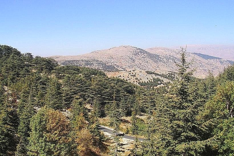
Landmark: Barouk Cedar Forest
City: Aley
Country: Lebanon
Continent: Asia
Barouk Cedar Forest, Aley, Lebanon, Asia
The Barouk Cedar Forest is a natural woodland reservation situated on the western slopes of Jabal Barouk within the Chouf District of Mount Lebanon Governorate, Lebanon. The site constitutes the largest contiguous forest cluster inside the Al Shouf Cedar Nature Reserve, preserving a key population of the endemic Cedrus libani species.
Visual Characteristics
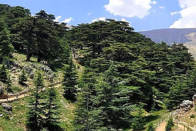
The Barouk Cedar Forest is characterized by mature stands of Lebanese cedar trees displaying their distinctive flat-topped, horizontal branching profiles, with individual specimens reaching heights of up to 30 meters. The understory consists of rugged karstified Jurassic limestone terrain, marked by rocky gray outcrops, deep crevices, and a light-brown organic topsoil layer mixed with fallen pine needles. The forest vegetation density transitions from dense, shaded canopies in the central valley to sparse, wind-sheared sub-alpine scrub and juniper at the upper ridgelines, which reach altitudes between 1,000 and 1,900 meters above sea level.
Location & Access Logistics
The Barouk Cedar Forest is located 52 kilometers southeast of Beirut and roughly 32 kilometers south of Aley. Access from Beirut is via the Southern Coastal Highway to Damour, exiting east onto the Kfarhim-Deir El Qamar-Beiteddine Highway, and continuing past Baqaata directly to the village of Barouk. An asphalt road leads from the village square up to the main eco-gatehouse, which features a designated gravel parking area for private vehicles. Public transit options are limited to regional minibuses connecting Beirut's Cola intersection to Baqaata, requiring a local taxi transfer to navigate the final 6 kilometers to the reserve entrance.
Historical & Ecological Origin
The forest sits on a porous, highly permeable anticlinal limestone fold formed during the Alpine orogeny, serving as a critical hydrological catchment area that supplies regional mountain springs. Historically, these cedar stands represent surviving fragments of the ancient post-glacial Levantine forests documented in the third millennium BC Sumerian Epic of Gilgamesh and later exploited for timber by Phoenician, Egyptian, and Roman administrations. The modern conservation framework was established in 1996 when national legislation incorporated the Barouk Cedar Forest into the Al Shouf Cedar Nature Reserve, protecting the ecosystem from logging, urban encroachment, and goat grazing to allow natural seed regeneration.
Key Highlights & Activities
Hiking the network of graded trails ranging from the short circular educational loops to the multi-kilometer mountain ridgeline treks.
Tracking native wildlife populations, including the Lebanese squirrel, wild boars, and migratory raptors crossing the Levant flyway.
Snowshoeing along the higher altitude forest corridors during the winter season when snow depth exceeds 0.5 meters.
Landscape photography from the high western crags, which provide open views toward the Beqaa Valley and Lake Qaraoun to the east.
Infrastructure & Amenities
The entry point features an operational Park House containing a ticketing office, basic map brochures, and a first-aid station. Eco-friendly wooden benches and directional signage are positioned at major trail intersections, though formal shade canopies are absent inside the core forest zones. Public flush toilets are available strictly at the main gatehouse installation. Cellular networks deliver stable 4G connectivity across most west-facing slopes, though signal attenuation and total dropouts occur within deep limestone ravines and on remote eastern ridgelines. No commercial food vendors or restaurants operate inside the reserve boundaries, but multiple local eateries are located in Barouk village 3 kilometers below.
Best Time to Visit
The optimal months for hiking and general visitation are from May to October for stable, dry weather conditions, and from January to March for winter snow sport activities. Photographic lighting conditions are optimal between 16:00 and 18:00 during late summer, when the low sun angle highlights the rough textures of the cedar bark and minimizes harsh exposures on the reflective limestone ground surfaces.
Facts & Legends
A historical boundary marker found near the upper perimeter dates to the reign of Roman Emperor Hadrian in the 2nd century AD. This stone engraving was part of an early imperial forest conservation initiative that declared the remaining cedar groves as part of the Emperor's private domain, strictly prohibiting unauthorized logging of straight-grained timber reserved for Roman naval vessels.
Nearby Landmarks
Barouk Village Square: 3.2km Northwest
Ain Zhalta-Bmohray Cedar Forest Gate: 4.8km North
Ammiq Wetland Eco-Reserve: 4.5km East
Shouf Highland Outpost: 3.9km North