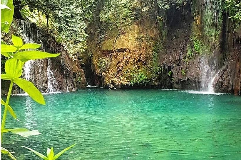
Landmark: Baakline Waterfalls (Shallalat al-Zarka)
City: Aley
Country: Lebanon
Continent: Asia
Baakline Waterfalls (Shallalat al-Zarka), Aley, Lebanon, Asia
The Baakline Waterfalls, known locally as Shallalat al-Zarka (The Blue Waterfalls), are a series of natural cascades located in the valley below the town of Baakline within the Chouf District of the Mount Lebanon Governorate, Lebanon. The site constitutes a riverine riparian ecosystem formed along the course of the Baakline River basin.
Visual Characteristics
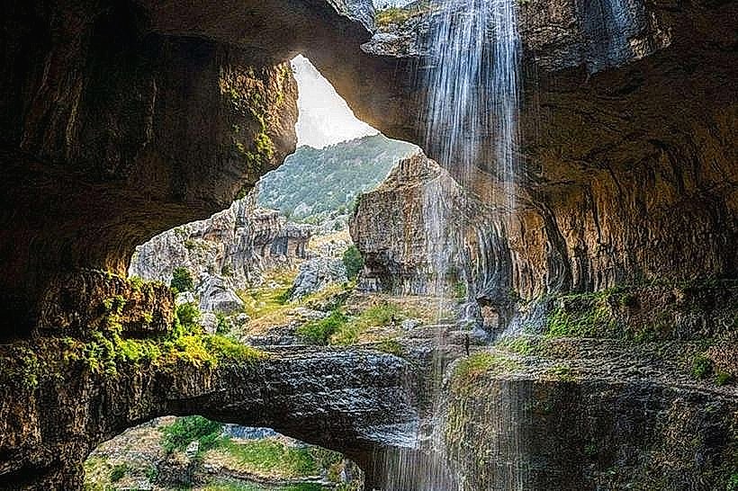
The Baakline Waterfalls (Shallalat al-Zarka) feature multiple distinct water drops varying between 5 and 12 meters in height, pouring over moss-covered limestone lips into broad natural plunge pools. The water is distinctively turquoise or clear blue due to the high calcium carbonate content of the mountain source spring. The surrounding valley is characterized by dense vegetation, including mature plane trees, wild willows, ferns, and hanging vines that cover the steep grey limestone rock walls enclosing the riverbed.
Location & Access Logistics
The site is situated approximately 45 kilometers southeast of Beirut and 4 kilometers southwest of the historic town of Deir el Qamar. Access from Beirut is via the Southern Coastal Highway to Damour, exiting east onto the regional highway toward Kfarhim and following the winding municipal roads descending into the Baakline valley. Paved private parking areas are maintained by the riverside establishments bordering the cascades. Public transport is limited to regional minibuses running from Beirut's Cola intersection to the Baakline town center, from which visitors must secure a local taxi to travel the remaining 3 kilometers down the steep valley road to the river level.
Historical & Ecological Origin
Geologically, the cascades are situated within a deeply incised river valley carved into Cretan limestone strata during the late Cenozoic era. The permanent hydrological flow is sustained by the large natural springs of the higher Chouf mountains, rendering this a vital freshwater riverine habitat within an otherwise seasonal Mediterranean landscape. Historically, the riverbanks and water power were utilized by local communities during the Maanid and Shihab emirates to operate stone flour mills, the foundations of which remain visible downstream.
Key Highlights & Activities
Observing the main 12-meter cascade dropping into the primary turquoise basin from the wooden viewing platforms.
Traversing the short pedestrian walkways that connect different tiers of the riverbed and the surrounding pools.
Examining the architectural remains of historic Ottoman-era stone bridges and mill structures located along the river loop.
Photography of the water flow patterns and reflecting pools beneath the shade of the dense plane tree canopy.
Infrastructure & Amenities
The immediate area surrounding the Baakline Waterfalls (Shallalat al-Zarka) is highly developed with private tourism infrastructure, primarily outdoor riverside restaurants and chalets built right along the water's edge. Public restrooms, dining tables, and shaded open-air seating areas are managed by these commercial venues. Cellular signal is stable, providing consistent 4G connectivity across all domestic networks due to proximity to the town infrastructure above. Potable public drinking fountains are unavailable, but commercial food and beverage vendors operate continuously at the site during the operating season.
Best Time to Visit
The optimal months for viewing maximum water volume are April and May during the peak of the spring thaw. The summer months from June to September are preferred for clear, calm water conditions and cooler microclimate conditions relative to the coast. Photographic lighting is most balanced between 11:00 and 13:00, when the overhead sun directly penetrates the narrow valley canopy, minimizing the harsh contrast between the deep shade of the trees and the highly reflective water surface.
Facts & Legends
Local oral history notes that the deep pools beneath the primary cascades were used as natural hideouts and cooling chambers by partisan fighters during regional conflicts in the 19th century. A specific deep pool, known colloquially by older residents as the "Blue Abyss," was long rumored to have no bottom due to the strong undercurrents and complex underwater limestone shelving that disoriented early local divers.
Nearby Landmarks
Baakline National Library (Historic Serail): 2.8km Northeast
Deir el Qamar Historic Town Center: 4.2km Northeast
Moussa Castle Museum: 4.6km Northeast
Mir Amin Palace: 4.9km East