Landmark: Akkar el-Atiqa Fortress
City: Akkar
Country: Lebanon
Continent: Asia
Akkar el-Atiqa Fortress, Akkar, Lebanon, Asia
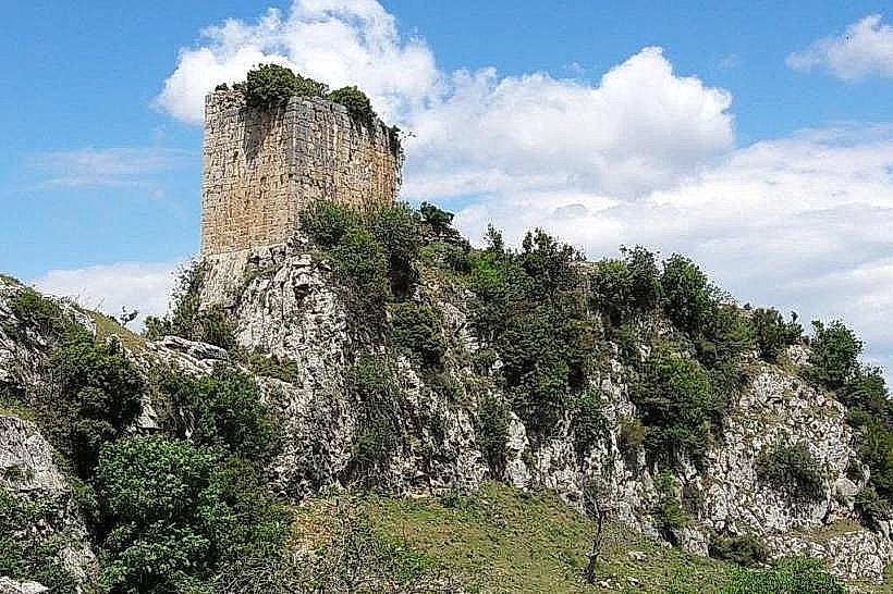
The Akkar el-Atiqa Fortress, historically documented as Gibelacar or Hisn Ibn Akkar, is a medieval fortification located near the mountain village of Akkar al-Atiqa within the Akkar Governorate of Northern Lebanon. The stronghold occupies a narrow, isolated rocky ridge at an elevation of 700 meters above sea level, commanding the transit routes across the Homs Gap.
Visual Characteristics
The Akkar el-Atiqa Fortress is constructed directly from local dark basalt and grey limestone blocks, spanning the entire length of a 200-meter-long structural spur. The site consists of two main defensive courts separated by a deep, rock-cut defensive ditch and flanked by the ruins of five rectangular towers. The most preserved architectural feature is the southern tower, which exhibits heavy medieval masonry and a distinctive decorative frieze of lions carved into its upper stone courses. The surrounding landscape features steep vertical drops into dual ravines carved by branches of the Nahr Akkar stream, surrounded by dense high-altitude pine, oak, and fir forests.
Location & Access Logistics
The site is positioned approximately 135 kilometers north of Beirut and roughly 40 kilometers northeast of the regional hub of Halba. Access from Tripoli is via the northern coastal highway toward Abdeh, turning inland through Halba and Al-Qoubaiyat onto the steep, winding mountain roads leading to Akkar al-Atiqa. The final approach requires a steep one-hour foot hike starting from a concrete bridge spanning the river at the base of the village ridge. No formal parking facilities are available at the trailhead, requiring vehicle placement along the rural road shoulder. Public transportation does not directly serve the fortress, limiting transit to private vehicles or local taxis hired from Halba.
Historical & Ecological Origin
The fortress was originally established around the year 1000 AD by Muhriz ibn Akkar and subsequently captured by the Mirdasid dynasty and Seljuk Turks. Crusader forces seized the complex in the early 12th century, renaming it Gibelacar and integrating it into the defensive network of the County of Tripoli. The Mamluk sultan Baibars reconquered and reinforced the fortification in 1271 following a heavy artillery bombardment. Geologically, the narrow spur is a volcanic and limestone ridge shaped by deep riverine erosion at the northernmost terminus of the Mount Lebanon range.
Key Highlights & Activities
Inspecting the carved Mamluk lion reliefs on the external face of the southern primary tower.
Examining the layout of the rock-cut defensive moat separating the lower and upper fortification courts.
Surveying the structural ruins of the vaulted subterranean rainwater cisterns located in the upper court.
Landscape photography from the southern tower ruins, providing unobstructed views of the Homs Gap and the Syrian border mountains.
Infrastructure & Amenities
The Akkar el-Atiqa Fortress is an unimproved, ruined historical monument with no formal public tourism infrastructure. There are no visitor center buildings, ticket offices, public restrooms, or built shade canopies at the site. No safety railings or modern barriers are installed along the steep 200-meter cliff perimeters. Cell phone connectivity is weak and highly variable due to the deep surrounding ravines, with unstable 3G or basic GSM signals common. Commercial food, water, and retail vendors are non-existent at the ruins, requiring all supplies to be carried up from the village square 3 kilometers away.
Best Time to Visit
The optimal period for visiting is from May to October when mountain hiking paths are dry and entirely free of winter mud or snow tracking. Photography is most effective between 07:00 and 09:00, when the low morning sun highlights the carved stone details of the southern tower faces and illuminates the deep river gorges before midday haze reduces regional visibility.
Facts & Legends
During the early Ottoman administration, the fortress served as a strategic stronghold for the powerful Sayfa clan before being partially dismantled around 1620 by the Druze Emir Fakhreddine II during a regional campaign to break their feudal autonomy. Local oral lore maintains that a hidden mountain spring was diverted via secret clay pipes directly into the main tower walls to maintain a permanent water supply during prolonged military blockades.
Nearby Landmarks
Al-Qammouah Pine Forest and Plain: 4.8km Southeast
Akkar al-Atiqa Village Square: 1.5km Southwest
Historic Al-Saqaa Suleiman Shrine: 1.2km West
Nahr Akkar Water Mills: 0.8km Northwest