Landmark: Canyonlands National Park
City: Moab
Country: USA Utah
Continent: North America
Canyonlands National Park, Moab, USA Utah, North America
Canyonlands National Park is a protected area in eastern Utah, USA, characterized by its vast canyons and mesas carved by the Colorado and Green Rivers.
The park is divided into four districts: Island in the Sky, The Needles, The Maze, and the rivers themselves.
Visual Characteristics
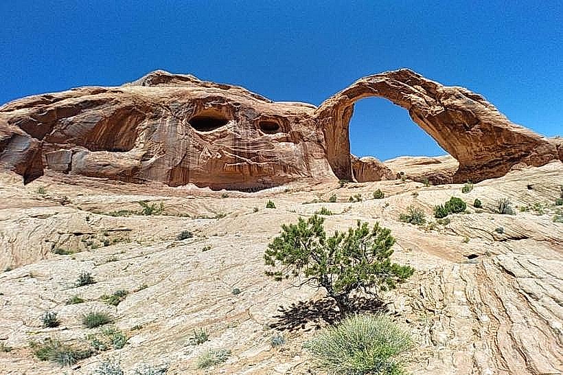
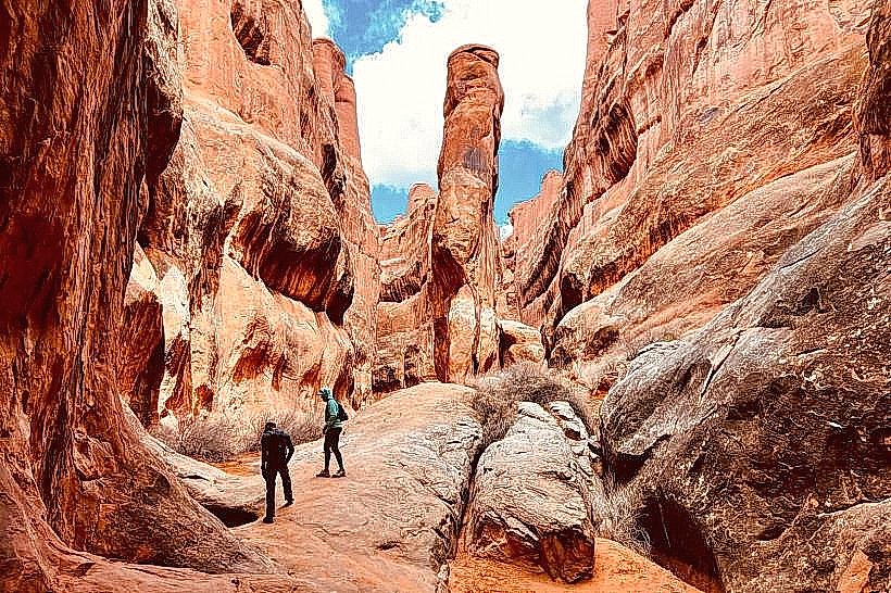
The landscape consists of deeply eroded sandstone canyons, mesas, and buttes. Rock layers exhibit colors ranging from deep red and orange to pale yellow and white, reflecting different geological eras. Vegetation is sparse, primarily consisting of drought-resistant shrubs, grasses, and cacti. Rock formations include towering spires, arches, and fins.
Location & Access Logistics
The main entrance to the Island in the Sky district is accessed via US-191 North from Moab, Utah, approximately 42 miles (68 km). The Needles district entrance is located off US-191 South, approximately 75 miles (121 km) from Moab. The Maze district requires high-clearance 4WD vehicles and is accessed via UT-24 and unpaved roads. Parking is available at designated lots within each district, with capacity varying by location and season. Public transport is not available within the park.
Historical & Ecological Origin
Canyonlands National Park was established in 1964. The landscape is a result of millions of years of geological processes, primarily erosion by water and wind acting on sedimentary rock layers deposited over 300 million years. The Colorado and Green Rivers are the primary erosional agents, cutting through the Colorado Plateau.
Key Highlights & Activities
Activities include hiking designated trails such as the Grand View Point Trail (Island in the Sky) and the Slickrock Trail (The Needles). Scenic drives are available on paved roads in Island in the Sky and The Needles. Off-road driving is permitted on designated routes in The Maze and parts of The Needles, requiring appropriate vehicles and permits. Stargazing is a significant activity due to low light pollution. Ranger-led programs are offered seasonally.
Infrastructure & Amenities
Restrooms are available at visitor centers and key viewpoints in Island in the Sky and The Needles. Limited shade structures are present at some picnic areas. Cell phone signal is generally absent or very weak throughout the park. No food vendors operate within the park; visitors must bring their own supplies. Water is available at visitor centers and some campgrounds.
Best Time to Visit
The best months for visiting are April, May, September, and October, offering moderate temperatures. Summer months (June-August) can reach extreme heat, exceeding 100°F (38°C). Spring and fall provide optimal lighting for photography, particularly during sunrise and sunset. No tide-dependent activities occur within the park.
Facts & Legends
The park contains evidence of human habitation dating back thousands of years, including Ancestral Puebloan granaries. A specific geological feature, the Upheaval Dome, has been the subject of scientific debate regarding its origin, with theories ranging from a meteorite impact to a salt dome collapse.
Nearby Landmarks
- Arches National Park (10km North-East)
- Dead Horse Point State Park (25km North-West)
- Mesa Verde National Park (150km South-East)
- Capitol Reef National Park (150km West)
- San Rafael Swell (100km West)